Sediment Transport
Overview
Sediment Transport Modeling within the Salish Sea Modeling framework is often conducted for three types of applications, (1) Flushing analysis using neutrally buoyant sediment particles, (2) Assessment of sediment deposition and erosion calculations in connection with channel maintenance and dredging for navigation, and (3) Sediment impact evaluations as part of nearshore restoration feasibility assessments. PNNL approach is to first conduct some preliminary analyses using the hydrodynamic model to provide estimates of current profiles and bed shear stress values. Often these estimates provide sufficient information and indication of potential for change in sediment deposition and erosion behavior relative to baseline conditions. However, some projects require quantitative estimates of deposition and erosion rates and computation of dredging volumes requiring full scale sediment transport modeling.
Projects

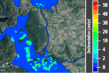
Hydrodynamic and Suspended Sediment Transport Model of Skagit and Padilla Bay System - a tool that can predict ecological consequences and likely impacts on the landscape from sea-level rise and future river flow and sediment load alteration, particularly in relation to the affects on coastal fisheries.

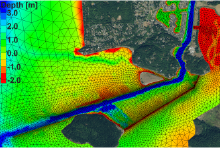
Sediment Transport into the Swinomish Navigation Channel - hydrodynamic and sediment transport modeling to evaluate the merits and demerits of proposed alternatives connected to the maintenance of dikes and jetties.
PNNL uses the Community Sediment Transport Model formulation of Warner et al. (2008). Its capabilities include the ability to couple with wave models, multiple sediment classes, suspended and bedload computations, bed slope, morphology, and sediment density effects. Suspended sediment transport calculations are conducted through source and sink terms through vertical settling and exchange with bed layer. Exchange with bed is conducted using erosion flux formulation of Ariathurai and Arulanandan (1978). Bed load computations are conducted using the Meyer-Peter Muller (1978) method. The models are typically set up using three sediment classes consisting of fine silt, silt, and fine sand based on sediment samples collected from the tide flats.