Tsunami Modeling
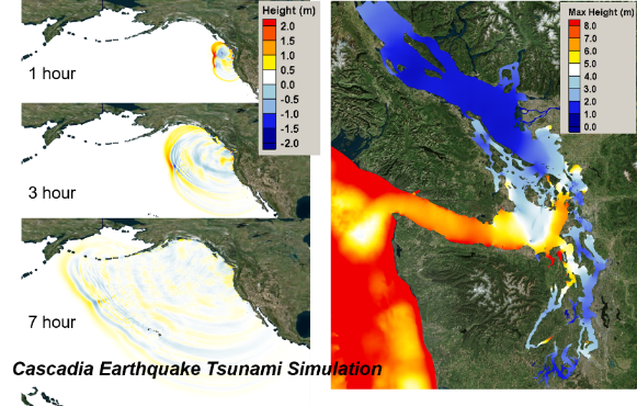
The U.S. Pacific Northwest (PNW) experiences a range of coastal hazards, including erosion and flooding enhanced by strong El Niño events, heavy rainfall and snowmelt associated with episodic severe windstorms (extratropical cyclones), extreme waves, storm surges, and King tides. However, the most extreme hazard to the PNW would be the occurrence of a Cascadia Subduction Zone (CSZ) earthquake and the induced tsunami. The damage of a tsunami on the PNW may be exacerbated by the combined effects of high tides and strong tidal currents as the tsunami waves propagate into coastal bays and estuaries. The CSZ is a convergent plate boundary along the West Coast of the United States stretching from northern Vancouver Island to northern California. The PNW is considered at high risk of a potential earthquake and tsunami in the foreseeable future. To better understand the dynamics and inundation of a tsunami in the PNW, numerical modeling can be a valuable tool for coastal hazard and emergency response planning. The Ocean Dynamics Modeling group is developing coastal modeling capabilities to investigate the nonlinear interactions between tsunami waves and tidal circulation and identify high-risk areas in Puget Sound and the Greater Seattle Area of the PNW.
Modeling a Tsunami and its Interaction with Tides along the Pacific Northwest Coast. A coupled tsunami–tide model is being developed to simulate the interaction between tsunami waves and tides. Preliminary model results suggest that the interaction between the two appear to be nonlinear. Because of the difference in tsunami and tidal periods, total water levels and velocities induced by the tsunami and tides can be increased or decreased at different phases of a tidal cycle and different locations in the Salish Sea.
