PNNL is leading the nation with research addressing urgent needs for reimagining U.S. critical infrastructure against the realities of software-speed attacks and hazards.
The Biodefense Policy Landscape Analysis Tool (B-PLAT), captures and presents a slew of information about U.S. efforts to protect its citizens and others around the world from diverse threats.
PNNL partnered with the Treasury and AWS to develop Cache, a cloud-based tool that allows the Treasury’s disparate data to be easily searched, translated, extracted, linked, and analyzed.
RemPlex provides a global forum committed to fostering technical leadership, collaborative research, and professional development that facilitates the cost-effective remediation of complex sites.
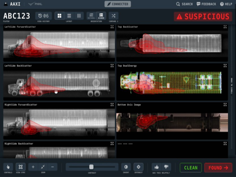
The CVAir pilot project transports computed tomography passenger baggage data from originating international airports for targeted flights destined for the U.S.
PNNL and ORNL are working together on Digital Twins to modernize the U.S. hydropower plant fleet, which will reduce operating costs, improve reliability, reduce downtime, enhance grid resiliency, and reduce environmental impacts.
In January 2024, CESER—in partnership with GDO, NASEO, and PNNL—created a set of state energy security cohorts to support the coordination and technical development of state energy security planning, assessment, and mitigation.
PNNL’s integrated software systems (FRAMES, MEPAS, MetView, APGEMS, CAPP) allow users to assess the environmental fate and transport of contaminants—and the potential impacts on humans and the environment—in a systematic, holistic approach.
PNNL is a leader in the integration of aberration-corrected electron microscopy, in-situ techniques, and atom probe tomography to address challenges in nuclear materials, environmental remediation, energy storage, and national security.
PNNL partners with agencies and industry to identify and engage historically disadvantaged populations in regulatory decision-making, environmental assessment, and impact estimation of the consequences of complex polices and projects.
GeoBOSS is a software library that combines the data-handling capabilities of Spark and the user-friendliness of Python to simplify geospatial analytics and the transition between small-scale research and large-scale operational projects.