
PNNL

  • About
  • News & Media
  • Careers
  • Events
  • Research
    • Scientific Discovery
      • Biology
        • Chemical Biology
        • Computational Biology
        • Ecosystem Science
        • Human Health
          • Cancer Biology
          • Exposure Science & Pathogen Biology
        • Integrative Omics
          • Advanced Metabolomics
          • Chemical Biology
          • Mass Spectrometry-Based Measurement Technologies
          • Spatial and Single-Cell Proteomics
          • Structural Biology
        • Microbiome Science
          • Biofuels & Bioproducts
          • Human Microbiome
          • Soil Microbiome
          • Synthetic Biology
        • Predictive Phenomics
      • Chemistry
        • Computational Chemistry
        • Chemical Separations
        • Chemical Physics
        • Catalysis
      • Earth & Coastal Sciences
        • Global Change
        • Atmospheric Science
          • Atmospheric Aerosols
          • Human-Earth System Interactions
          • Modeling Earth Systems
        • Coastal Science
        • Ecosystem Science
        • Subsurface Science
        • Terrestrial Aquatics
      • Materials Sciences
        • Materials in Extreme Environments
        • Precision Materials by Design
        • Science of Interfaces
        • Solid Phase Processing
          • Cold Spray
          • Friction Stir Welding & Processing
          • ShAPE
      • Nuclear & Particle Physics
        • Dark Matter
        • Fusion Energy Science
        • Neutrino Physics
      • Quantum Information Sciences
    • Energy Resiliency
      • Electric Grid Modernization
        • Emergency Response
        • Grid Analytics
          • AGM Program
          • Tools and Capabilities
        • Grid Architecture
        • Grid Cybersecurity
        • Grid Energy Storage
        • Transmission
        • Distribution
      • Energy Efficiency
        • Appliance and Equipment Standards
        • Building Energy Codes
        • Building Technologies
          • Advanced Building Controls
          • Advanced Lighting
          • Building-Grid Integration
        • Building and Grid Modeling
        • Commercial Buildings
        • Federal Buildings
          • Federal Performance Optimization
          • Resilience and Security
        • Residential Buildings
          • Building America Solution Center
          • Energy Efficient Technology Integration
          • Home Energy Score
        • Energy Efficient Technology Integration
      • Energy Storage
        • Electrochemical Energy Storage
        • Flexible Loads and Generation
        • Grid Integration, Controls, and Architecture
        • Regulation, Policy, and Valuation
        • Science Supporting Energy Storage
        • Chemical Energy Storage
      • Environmental Management
        • Waste Processing
        • Radiation Measurement
        • Environmental Remediation
      • Fossil Energy
        • Subsurface Energy Systems
        • Carbon Management
          • Carbon Capture
          • Carbon Storage
          • Carbon Utilization
        • Advanced Hydrocarbon Conversion
      • Nuclear Energy
        • Fuel Cycle Research
        • Advanced Reactors
        • Reactor Operations
        • Reactor Licensing
      • Renewable Energy
        • Solar Energy
        • Wind Energy
          • Wind Resource Characterization
          • Wildlife and Wind
          • Community Values and Ocean Co-Use
          • Wind Systems Integration
          • Wind Data Management
          • Distributed Wind
        • Marine Energy
          • Environmental Monitoring for Marine Energy
          • Marine Biofouling and Corrosion
          • Marine Energy Resource Characterization
          • Testing for Marine Energy
          • The Blue Economy
        • Hydropower
          • Environmental Performance of Hydropower
          • Hydropower Cybersecurity and Digitalization
          • Hydropower and the Electric Grid
          • Materials Science for Hydropower
          • Pumped Storage Hydropower
          • Water + Hydropower Planning
        • Grid Integration of Renewable Energy
        • Geothermal Energy
      • Transportation
        • Bioenergy Technologies
          • Algal Biofuels
          • Aviation Biofuels
          • Waste-to-Energy and Products
        • Hydrogen & Fuel Cells
        • Vehicle Technologies
          • Emission Control
          • Energy-Efficient Mobility Systems
          • Lightweight Materials
          • Vehicle Electrification
          • Vehicle Grid Integration
    • National Security
      • Chemical & Biothreat Signatures
        • Contraband Detection
        • Pathogen Science & Detection
        • Explosives Detection
        • Threat-Agnostic Biodefense
      • Cybersecurity
        • Discovery and Insight
        • Proactive Defense
        • Trusted Systems
      • Nuclear Material Science
      • Nuclear Nonproliferation
        • Radiological & Nuclear Detection
        • Nuclear Forensics
        • Ultra-Sensitive Nuclear Measurements
        • Nuclear Explosion Monitoring
        • Global Nuclear & Radiological Security
      • Stakeholder Engagement
        • Disaster Recovery
        • Global Collaborations
        • Legislative and Regulatory Analysis
        • Technical Training
      • Systems Integration & Deployment
        • Additive Manufacturing
        • Deployed Technologies
        • Rapid Prototyping
        • Systems Engineering
      • Threat Analysis
        • Advanced Wireless Security
          • 5G Security
          • RF Signal Detection & Exploitation
        • Internet of Things
        • Maritime Security
        • Millimeter Wave
        • Mission Risk and Resilience
    • Data Science & Computing
      • Artificial Intelligence
      • Graph and Data Analytics
      • Software Engineering
      • Computational Mathematics & Statistics
      • Future Computing Technologies
        • Adaptive Autonomous Systems
    • Publications & Reports
    • Featured Research
  • People
    • Inventors
    • Lab Leadership
    • Lab Fellows
    • Staff Accomplishments
  • Partner with PNNL
    • Education
      • Undergraduate Students
      • Graduate Students
      • Post-graduate Students
      • University Faculty
      • University Partnerships
      • K-12 Educators and Students
      • STEM Education
        • STEM Workforce Development
        • STEM Outreach
        • Meet the Team
      • Internships
    • Community
      • Regional Impact
      • Philanthropy
      • Volunteering
    • Industry
      • Available Technologies
      • Industry
      • Industry Partnerships
      • Licensing & Technology Transfer
      • Entrepreneurial Leave
      • Visual Intellectual Property Search (VIPS)
  • Facilities & Centers
    • All Facilities
      • Atmospheric Radiation Measurement User Facility
      • Electricity Infrastructure Operations Center
      • Energy Sciences Center
      • Environmental Molecular Sciences Laboratory
      • Grid Storage Launchpad
      • Institute for Integrated Catalysis
      • Interdiction Technology and Integration Laboratory
      • PNNL Portland Research Center
      • PNNL Seattle Research Center
      • PNNL-Sequim (Marine and Coastal Research)
      • Radiochemical Processing Laboratory
      • Shallow Underground Laboratory

Error message

Could not retrieve the oEmbed resource.

Center for the Remediation of Complex Sites

  • About RemPlex
    • History
    • Leadership
    • Working with PNNL
    • Learn and Study
  • Seminars
  • Workshops
  • Past Summits
    • 2023 Summit
    • 2021 Summit
  • 2025 Summit
    • Program-at-a-Glance
    • Case Studies
    • Technical Sessions
    • Sponsors

Breadcrumb

  1. Home
  2. Projects
  3. Center for the Remediation of Complex Sites
  4. RemPlex 2021 Summit
  5. RemPlex Summit Technical Sessions

RemPlex Summit Technical Sessions

TechnicalSession1

Subsurface Remote Sensing for Contaminant Characterization and Remediation Applications

Nov. 8, 2021, 10:15 am - 11:45 am

Organizer(s): Lee Slater, Rutgers University, New Brunswick, New Jersey; Tim Johnson and Fred Day-Lewis, Pacific Northwest National Laboratory (PNNL), Richland, Washington

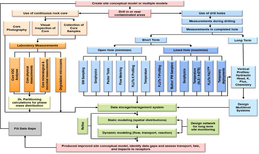
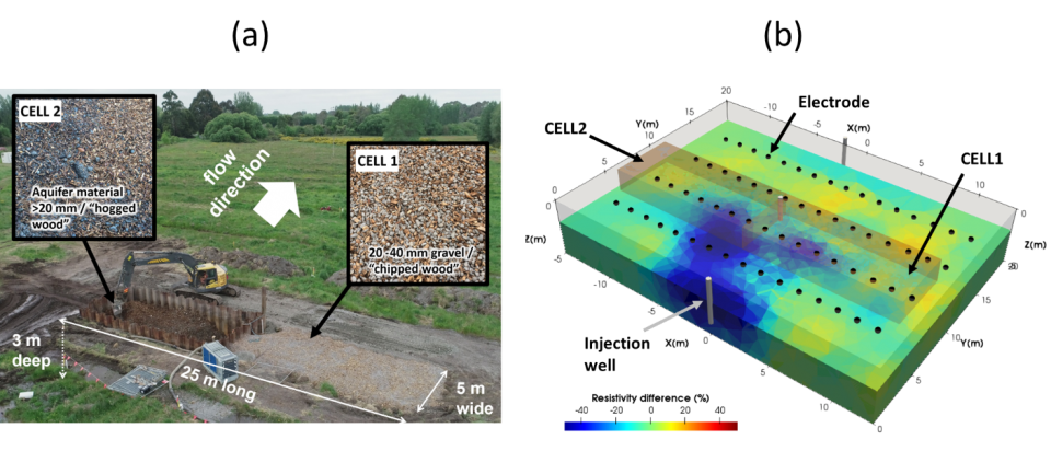
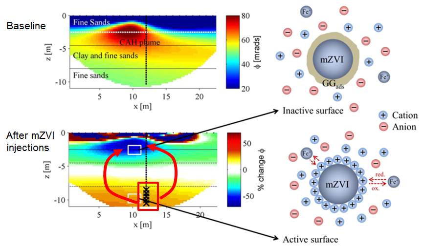
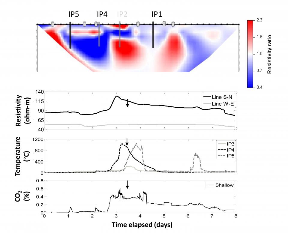
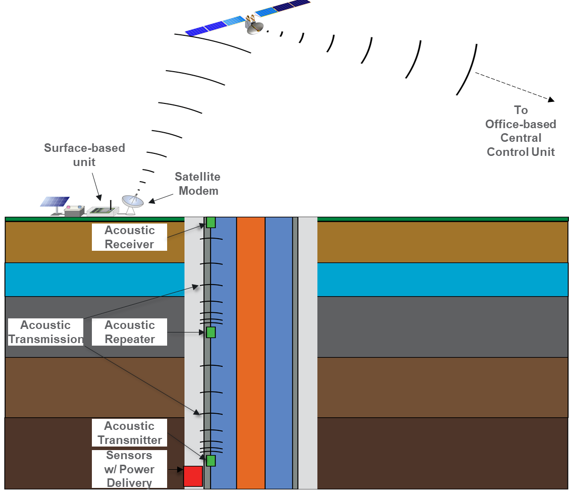
The combined effects of subsurface heterogeneity and inaccessibility and the corresponding inability to adequately sample the subsurface impedes understanding of subsurface environments and can lead to increased remediation costs, suboptimal remediation performance, and risks to human health and the environment. Geophysical methods can provide a significant and cost-effective source of information that reduces cost and risk. This technical session highlights novel uses of subsurface remote sensing to characterize and monitor contaminated sites. Topics range from the interpretation of geophysical data in terms of (bio)geochemical reactions to autonomous 3D monitoring of engineered remediation processes.


VIEW ALL TECHNICAL SESSIONS

Nov. 8 Technical Session Recording Now Available

Introduction

beth parker

University of Guelph, Ontario, Canada

Using Temporary Deployed Sensors in Bedrock Boreholes to Improve Remediation Decisions & Monitoring at Complex Sites

Co-authors: Jonathan Munn, Carlos Maldaner, and Peeter Pehme, University of Guelph

Abstract

Characterization of contaminant distributions in fractured rock systems is both common and exceptionally challenging. In fractured rock systems, nearly all groundwater flow and downgradient contaminant transport occurs in the interconnected fracture network (secondary porosity), yet not all fractures are well-connected or equally transmissive. In sedimentary rocks, it is well-known that mass transfer between fractures and the lower permeability, porous rock matrix strongly affects contaminant plume behavior and remedial efficacy. In metamorphic and igneous bedrock (e.g. granite) the matrix porosity can be much lower, however still appreciable relative to fracture porosity, and in many cases enhanced by micro-fractures. A fundamental question in these systems is determining the number of hydraulically active fractures that influence average linear groundwater velocities and surface area for diffusion affecting plume front migration rates to assess risks and internal mass flux distributions needed to enhance remediation performance. Several new high-resolution field methods have been developed and tested for identifying hydraulically active fractures in bedrock boreholes where sensors can be temporarily deployed behind FLUTe liners (Keller et al. 2014). These liners allow re-creation of ambient flow system conditions, improved sensitivity active fracture identification and identification of aquitard occurrence from direct measurement of hydraulic head and flow. The updated DFN-M field approach provides an expanded toolkit for creating process-based CSMs and re-use boreholes for effective monitoring zone placement, optimizing site remediation costs. 

ParkerFigure
Fractured rock site characterization framework using multiple, high-resolution methods to inform DFM process-based Conceptual Site Models for remediation (from Parker et al., 2012). Temporary deployed sensors for direct measurement of hydrogeologic system parameters offer cost-effective options for “calibrating” geophysical and geologic data.


Theme: Environmental Remediation

Speaker #1
Andrew Binley

Lancaster Environment Centre, Lancaster University, Lancaster

Electrical Resistivity Imaging of Denitrifying Permeable Reactive Barriers

Co-authors: Lee Burbery and Theo Sarris, Institute of Environmental Science and Research, Christchurch, New Zealand; Richard Mellis and Mike Finnemore, Southern Geophysical Ltd., Christchurch, New Zealand; Giorgio Cassiani, Universita di Padova, Padova, Italy; Michael Tso, UK-CEH, Lancaster, UK

Abstract

Many parts of the world are experiencing increasing concentrations of nitrate in groundwater.  Woodchip denitrifying permeable reactive barriers (PRBs) enhance in situ natural nitrate attenuation in shallow groundwater systems. Solid carbon is added in trenches through the aquifer to intercept nitrate-contaminated groundwater flow. A critical element in the design of such PRBs is matching hydraulic conductivity of the PRB to the surrounding aquifer media to ensure that water flows through the PRB rather than around it.   In this case study we illustrate how electrical geophysics is being used to assess the performance of denitrifying PRBs installed in gravel aquifers of the Canterbury region, New Zealand.   A particular challenge of the setting is the very high advective velocity of local groundwater. We have used a series of solute tracer experiments coupled with time-lapse electrical resistivity imaging and solute transport modelling to characterise flow paths and residence times of groundwater in and around two trial PRBs. Electrical resistivity imaging has revealed surprisingly complex solute pathways within the PRBs, and highlight the potential degrading of hydraulic performance of the PRBs, which may limit their remediation effectiveness. 

BinleyImage
(a) Installation of two denitrifying PRBs at the field site (Canterbury, New Zealand). (b) Example time-lapse electrical resistivity image showing solute pathway 12 hours after tracer injection.
 

Speaker #2
Adrián Flores-Orozco

Technical University of Vienna, Vienna, Austria

Monitoring the Injection of Nanoparticles for Groundwater Remediation by Means of Complex Conductivity

Co-authors: Jakob Gallistl, TU Wien, Vienna, Austria; Matthias Bücker, TU Braunschweig, Germany

Abstract

It has been demonstrated that subsurface amendment with nano- and micro-scale particles speeds up the degradation of pollutants and has the potential to reach areas not accessible with other methods. The high reactivity of the particles calls for the monitoring of subsurface changes in real time to evaluate the correct delivery of the particles into the target and the degradation of pollutants. This vital information cannot be gained through traditional borehole sampling. Here, we present complex conductivity (CC) results obtained along experiments conducted at the field scale (a) for data collected along the injection of Goethite nanoparticles (GNP) for the degradation of Toluene and (b) for data collected along the injection of micro-scale zero-valent iron (mZVI) particles to treat a plume of chlorinated aliphatic hydrocarbons (CAH). CC measurements were collected using electrodes placed on the surface and the measuring protocol was designed to collect a complete data set within 15 minutes.

For both presented experiments, initially high electrical conductivity values associated to the mature contaminant plumes decrease due to the injection of the solution containing the GNP and mZVI particles. Unexpectedly, large variations in the electrical images were resolved in the unsaturated zone and close to the surface (Fig. 1). The analysis of the affected sediments revealed the accumulation of particles due to an unexpected migration through fractures developed during injection, also confirmed by daylighting observed in wells up gradient from the injection point. Furthermore, the increase of the conductivity phase values indicates the degradation of the brush layer (coating mZVI) and interactions with the contaminants (see Fig. 1). Our results demonstrate that CC imaging permits to assess in real-time the path of the injected particles and their transformation. Accordingly, CC can be used to monitor in real-time changes in the subsurface due to particles injections and other in-situ remediation strategies.

FloresFigure
Complex conductivity imaging results for baseline data (top) and relative change (bottom) after the injection of mZVI, expressed in terms of the conductivity phase (ϕ).

 
Speaker #3
christopher power

Western University, Ontario, Canada

Numerical, Laboratory and Field Assessment of Electrical Resistivity Imaging of DNAPL Remediation

Co-authors: Jason Gerhard, Western University; Panagiotis Tsourlos, Aristotle University of Thessaloniki; 

Abstract

The remediation of sites contaminated with industrial chemicals – specifically dense non-aqueous phase liquids (DNAPLs) like coal tar and chlorinated solvents - remains a major geoenvironmental challenge. Remedial activities would benefit from a non-destructive technique to map the evolution of DNAPL mass in space and time. Electrical resistivity tomography (ERT) has long exhibited strong potential in this context but has yet to become a common tool at DNAPL sites. This presentation summarizes our numerical, laboratory and field studies that assesses the potential of time-lapse ERT for improved monitoring of DNAPL remediation. A new coupled DNAPL-ERT numerical model was developed and then employed to explore time-lapse ERT for monitoring a range of realistic DNAPL remediation scenarios at the field-scale. Laboratory tank experiments were also conducted to assess a new surface-to-horizontal borehole configuration for improved ERT mapping of DNAPL remediation. Finally, ERT was used to successfully monitor a DNAPL source zone undergoing thermal remediation at an industrial field site in New Jersey, USA. Overall, this body of work demonstrates that ERT is indeed promising for mapping DNAPL remediation, benefitting from recent advancements in this technique, including data acquisition, instrumentation and inversion.

PowersFigure
Ratio image during time-lapse ERT monitoring of DNAPL remediation at a field site, along with evolving electrical resistivity, soil temperature and carbon dioxide measurements recorded at one location.


Speaker #4
samuel falzone

Army Corps of Engineers/Cold Regions Research and Engineering Laboratory, Hanover, New Hampshire

Early Evidence for Complex Resistivity as a Geophysical Field Method to Delineate PFAS Contamination

Co-authors: Ethan Siegenthaler, Kristina Keating, and Lee Slater, Rutgers University Newark; Charles Schaefer, CDM Smith; Dale Werkema, Environmental Protection Agency

Abstract

The distribution of polyfluoroalkyl substances (PFAS) in aqueous film forming foam (AFFF)-impacted source areas remains poorly understood, despite the growing urgency to deal with PFAS contamination. New field methods to delineate and characterize source zones are needed to better understand the fate of these contaminants in the subsurface, and to better assist with site management and future remediation efforts. While direct sampling and laboratory analysis for PFAS constituents are possible, these efforts result in sparse sampling of the affected area. Geophysics has the potential to provide a means to characterize AFFF-impacted source zones, within which PFAS contamination is more concentrated, on a more relevant spatial and temporal scale than direct sampling. The imaginary conductivity (’’) as measured with Complex Resistivity (CR) measurements is sensitive to changes in surface charge associated with cation sorption. As PFAS is known to closely associate with the pore surface, CR seems a likely choice to study environmental PFAS contamination. To assist with the ongoing effort to better address PFAS contamination, we explore the potential for CR to characterize PFAS contaminated source zones through a series of bench-scale experiments and field surveys.

In bench-top studies we have observed promising trends in synthetic and legacy contaminated soils indicating that ’’ is sensitive to the presence of PFAS contamination. We have also observed trends in soils treated to remove PFAS that further indicates sensitivity of ’’ to PFAS concentrations. In addition to laboratory data, we present early field evidence that CR surveys can delineate variations in PFAS concentrations associated with a legacy source zone of contamination.


Speaker #5
hilary p. emerson

Pacific Northwest National Laboratory (PNNL), Richland, Washington

Spectral Induced Polarization for Monitoring In Situ Remediation at Department of Energy's Hanford Site

Co-authors: James E. Szecsody, Amanda Lawter, Eleda Fernald, Adam Mangel, Judy Robinson, Nikolla Qafoku, and Vicky Freedman, PNNL, Richland, Washington; Christopher Halter, Eastern Washington University, Cheney, Washington 

Abstract

Groundwater sampling and sediment coring have been reliably used to infer biogeochemical reactions occurring in situ during active and passive remediation. While these techniques are informative, there are disadvantages including (1) the challenge of selecting representative locations for point sampling and (2) high costs associated with monitoring well installation and sampling. Noninvasive geophysical tools can monitor large volumes of the subsurface with relatively high spatial resolution to infer solution and surface biogeochemical changes over time. Along with traditional sampling, geophysical methods can be used (1) during active remediation as indirect indicators of contaminant transformations and (2) as part of an overall strategy for long-term monitoring of subsurface contaminated sites. 
 
Spectral induced polarization (SIP) is a geophysical technique that is sensitive to solution properties (e.g., ionic strength) and surface reactions (e.g., adsorption, precipitation) that modify surface properties (e.g., surface area, grain size, polarizability). Laboratory column experiments were conducted to collect SIP data for different remediation amendments applicable to ongoing cleanup efforts at the Hanford Site (Washington, USA), including zero valent iron (ZVI), sulfur-modified zero valent iron (SMI), calcite, and apatite. Experiments were conducted in saturated columns with concurrent monitoring of major geochemical parameters (e.g., solution conductivity, pH, oxidation-reduction potential, and dissolved oxygen) to identify the (1) sensitivity for detection of individual amendments in static (no-flow) conditions, (2) detectability of amendments during in situ injection and precipitation, and (3) change in SIP signal over time to quantify change in amendment reactivity. The greatest sensitivity was observed for conductive materials, including ZVI and SMI, with detection limits as low as 0.2 wt.% based on phase shifts and imaginary conductivity measured via SIP. Shifts in phase and imaginary conductivity peaks measured by SIP were also observed due to changes in amendments over time suggesting changes in reactivity. Apatite and calcite had a greater response at higher concentrations which may be due to physical changes in porosity from precipitation rather than the mineral phase. These results demonstrate a first step for validating SIP as a method for field-scale monitoring remediation activities at Hanford and other sites.

.   

Theme: Environmental Site Characterization and Monitoring

Speaker #1
roelof versteeg

Subsurface Insights, Hanover, New Hampshire

Integration of Measurements, Modeling and Parameter Estimation for a Predictive Site Understanding

Co-authors: Rebecca Rubinstein, Ali Meyal, Haiyan Zhou, Subsurface Insights; Reza Soltanian, University of Cincinnati; Aaron Peacock, Microbac

Abstract

Effective site remediation requires auditable and transparent integration of analytical tools with multi scale and multi domain measurements and models. This integration should be centered around reactive transport models which can predict fate and transport of contaminants.

One major challenge is that while reactive transport models can directly accommodate and use several datasets (such as hydrological head data or concentration data), it has been challenging to use other data or models.

For instance, timelapse electrical resistivity data has been shown to be extremely informative for contaminant behavior, but is not something which can be easily integrated in reactive transport models. Similarly, microbiological data contains large amounts of information about key processes, but is not something which is readily integrated in reactive transport data.

We will present progress results on a powerful integrated framework (Predictive Assimilation Framework) which provides comprehensive data management, analytics and modeling capabilities which jointly provide actionable understanding of system behavior.

We will discuss two components. The first one – Omics to Reactive Transport (ORT – Figure 1) provides a streamlined workflow to couple microbe-scale and macroscale processes using the outputs of KBASE and PFLOTRAN. It does this in an iterative manner, allowing there to be a process level coupling which avoids a lot of the standard scaling challenges.

VersteegFigure1
Figure 1 Omics to Reactive Transport (ORT) workflow couples microbe-scale and macroscale processes using the outputs of KBase and PFLOTRAN as inputs for each other.

The second component is novel autonomous electrical geophysical monitoring hardware which is integrated with a data management, processing and parameter estimation pipeline which couples E4D, PEST and PFLOTRAN in a data domain approach to effectively utilize timelapse electrical geophysical data in the optimization of reactive transport models (Figure 2).

VersteegFigure2
Figure 2. Data domain approach for coupling time lapse electrical geophysical data with reactive transport models


Speaker #2
hang chen

Boise State University, Boise, Idaho

Improving Subsurface Characterization with Sequential Inversion of Multiple Geophysical Datasets

Co-authors: Qifei Niu, Boise State University

Abstract

Subsurface heterogeneity impedes our understanding of the hydrological conditions of contaminated sites. In the last several decades, geophysical methods have been frequently used in characterizing the contaminated subsurface due to cost-effectiveness and invasive nature of the technique. Since the hydrological conditions of many sites are very complex, traditional geophysical tests with a single imaging method may not fully resolve the heterogeneity needed in subsurface remediation modeling for predictive understanding. In particular, smoothness constraint imposed by regularization, which is necessary to make the optimal solution unique, may induce significant biases to the estimated hydrological properties even if the hydrogeophysical models are known and related model parameters are accurate.

In this study, we propose a sequential inversion method for subsurface characterization with seismic travel-time data and electrical resistivity data. The seismic travel-time data are first inverted to generate the spatial distribution of the seismic velocity, which is then used to determine the structural characteristics of the subsurface. The subsurface is then divided into zones featuring different structural properties, and these zones are then used to guide the inversion of resistivity data. In the guided resistivity inversion, the regularization (i.e., smoothness constraints) across the boundary between two zones are relaxed to preserve the discontinuity. Two synthetic models and two field cases are used to demonstrate the use of the proposed inversion. Archie’s law is used to translate the inverted resistivity into water content in a stochastic way such that the uncertainty induced by inaccurate model parameters can also be quantified. The results show that the proposed inversion strategy can help reduce the biases induced by the smooth constraint of the regularization and thus can be applied for subsurface hydrological characterization.

HangImage
The estimated water content distributions of two field sites using sequential inversion: (a) mean value and (b) uncertainty for site 1, and (c) mean value and (d) uncertainty of site 2.


Speaker #3
judy l. robinson

Pacific Northwest National Laboratory (PNNL), Richland, Washington

Electrical Mapping of Paleochannels Demonstrating the Value of Non-invasive Imaging at the Hanford Site

Co-authors: J. Thomle, D. McFarland, K. Deters, M. Rockhold, F. Day-Lewis, V. Freedman, PNNL, Richland, Washington

Abstract

Characterization of aquifer structure (e.g., geologic contacts, structures, and lithology) remains a major challenge in hydrogeology despite decades of research in subsurface imaging and hydrologic parameter estimation. A critical component of aquifer structure is transmissive stratigraphic features, or paleochannels, which create preferential hydraulic connections and allow downgradient migration of groundwater contamination. Incorporating the location(s) of these features in a geologic framework model (GFM) directly supports conceptual and reactive transport model development which is necessary for focused and effective remedial action. At the Hanford Site in WA, USA, paleochannels are buried ancestral fluvial channels associated with the Columbia River and cataclysmic Ice Age floods. The approximate location of these stratigraphic features has been inferred through interpolation of physical and chemical borehole data including geophysical logs, grain-size analyses and contaminant concentrations. Where there is sparse borehole coverage or incomplete data from wells, the interpolation between locations is uncertain. Non-invasive geophysical imaging can play an important role in filling gaps between boreholes and reducing characterization costs.

We present a case study using large scale electrical mapping to identify hydrostratigraphy and potential paleochannels at the Hanford Site. In two field campaigns, over 36 line-kilometers (km) of electrical resistivity tomography (ERT) data were collected along 14 transects. ERT is highly effective at the Hanford Site because lithologic contrasts have associated contrasts in electrical conductivity. ERT surveys were sited and performed to image critical aspects (e.g., paleochannels, stratigraphic contacts) of the subsurface. Inconsistencies between the GFM and ERT were catalogued to provide a basis for future site characterization using complementary geophysical methods and (or) direct sampling. A general workflow will be presented for using ERT to confirm, refine, or reject aspects of a GFM.

RobinsonFigure1
Large-scale 2D ERT images where electrical structure can serve as a proxy for hydrostratigraphic structure. Deviations in structure from the GFM were flagged for further investigation.


Speaker #4
Xiaoqin Zang

Pacific Northwest National Laboratory (PNNL), Richland, Washington

Acoustic Communication Along Drill Strings for Deep Subsurface Monitoring 

Co-authors:  Jayson J Martinez, Aljon Salalila, Orlando A Garayburu Caruso, Christopher E Strickland, Z. Daniel Deng, PNNL; Yang Yang, Chinese Academy of Science

Abstract

Subsurface monitoring at a carbon storage site is important for tracking the movement of CO2 and the status of the site for geologic storage. Therefore, advanced monitoring technologies and effective methods to transmit data from downhole to the surface are needed to reduce the cost and uncertainty in measurements and satisfy regulations for tracking the fate of subsurface CO2. This study covers the design, development, and initial laboratory-scale feasibility study of an acoustic communication system for monitoring the deep subsurface. We set up a metal tubing in a lab space as the model and designed a hardware system for acoustic signal transmission and data collection. Tri-axis accelerometers were installed at eleven locations on the testing tube to receive the encoded-signals transmitted from a PZT transducer. The signal attenuation along the string and the impulse response of the acoustic channel were investigated. Using an inverse filter processing method, communication signals were successfully recovered and decoded with zero bit errors at all testing locations when the signal-to-noise ratio is 0 dB. 

ZangFigure
Real-time, wireless access to sensor data using acoustic telemetry for monitoring the deep subsurface.


PNNL

  • Get in Touch
    • Contact
    • Careers
    • Doing Business
    • Environmental Reports
    • Security & Privacy
    • Vulnerability Disclosure Policy
  • Research
    • Scientific Discovery
    • Energy Resiliency
    • National Security
Subscribe to PNNL News
Department of Energy Logo Battelle Logo
Pacific Northwest National Laboratory (PNNL) is managed and operated by Battelle for the Department of Energy
  • YouTube
  • Facebook
  • X (formerly Twitter)
  • Instagram
  • LinkedIn