June 18, 2024
News Release

City Sprawl Now Large Enough to Sway Global Warming Over Land

Urban land now reaches farther than ever, and so too does its influence on global warming

The glowing orange Sun shines over a lightly hazy Paris, the Eifel Tower standing erect, just right of center-frame.

Cities have grown quite a lot in recent decades—global urban land cover has swelled by 226 percent since 1992. As city sprawl expands its reach, its influence on the world's climate grows in tandem. 

(Image by Pedro Kümmel | Unsplash.com)

RICHLAND, Wash.—Just how much heat does city sprawl add to large-scale warming? That’s one longstanding question researchers sought to answer in a new study recently published in the journal One Earth. 

Once thought to cover too little of the Earth’s surface to affect climate at larger scales, the new work suggests that urbanization does indeed have a detectable influence on global warming over land, with more to potentially follow as cities continue growing. 

The effect is most dramatic in some of the world’s most rapidly urbanizing areas. In the bustling Yangtze River Basin, for example, home to more than 480 million people (one third of China’s total population), urban sprawl contributed nearly 40 percent of the area’s increased warming between 2003 and 2019. 

In Japan, where close to 10 percent of total land is developed, urbanization contributed a quarter of the added warming observed during the study period. The urban signal was less pronounced in Europe and North America, where urbanization boosted roughly 23 percent of warming. That’s likely because much of the development there happened before the study period and, proportionally, there is still a great deal of undeveloped land compared to other smaller regions and countries. 

Overall, cities added just over one percent of increased land surface warming across the entire globe; 1.3 percent during daytime and 1.1 percent during nighttime.

“Urbanization” is an umbrella term of sorts. It encompasses not only built structures in cities, but also the many climate-influencing factors like air pollution, city parks and swelling populations that are tied to their existence.

The urban climate signal

Traditionally, cities are either left out of global climate models or represented in very simplistic ways, according to the study authors. When climate scientists use these models to understand how extreme weather may change in a warmer world, for example, they rarely factor cities into their simulations. But if they’re included at all, cities aren’t depicted as growing, changing entities, even though the rest of the world is projected to change decades into the future.

That’s a shortcoming, said lead author and Earth scientist TC Chakraborty at the Department of Energy’s Pacific Northwest National Laboratory. A large body of research demonstrates that cities influence the climate around us in a myriad of ways.

Buildings absorb and trap heat, which means cities take much longer to warm and cool down than rural areas. In some cases, this could mean city dwellers may spend more time in uncomfortable heat than their countryside neighbors. Cityscapes can change the way air moves around us, or even intensify extreme weather

While the influence of urban land has been clear at the local scale, researchers have questioned whether cities matter at the regional, continental and planetary scales.

“The answer is yes, they do; to a small extent,” said Chakraborty. “Urbanization does have a detectable impact on global land warming. That impact is minor but statistically significant at the global land scale, and particularly evident at continental scales. When you zoom into specific regions of the world, the effects can get quite large.”

It depends on where you look, Chakraborty added. In the case of Greenland, where very little urban land was added during the study period, city sprawl didn’t pose much of an impact on large-scale warming. But in rapidly urbanizing areas like certain parts of Asia, the authors saw strong, large-scale warming that stemmed from urbanization.

Although cities have grown sufficiently large to affect the global climate, their effect remains small when compared to that of greenhouse gas emissions and other anthropogenic changes. The new findings counter a common point of skepticism, said Chakraborty.

“Some argue that the urban heat island effect is a dominant contributor to large-scale climate warming. Our findings demonstrate that this is untrue: the impact of the urban heat island on global land warming is statistically significant, but it’s far from the major contributor. Our population-scale estimate of this warming using satellite data effectively demonstrates that,” said Chakraborty.

Moreover, the urban effect on climate is complex, he added. Earlier this year, Chakraborty and other PNNL researchers showed that one arid desert city partly cooled as it developed. They found that adding more parks and farmland than is naturally possible in an arid background climate helped the city to partially buck the global warming trend. 

The authors observed a similar effect in the new work, finding that India and Africa, the latter including many arid cities, showed daytime urban cooling signals as cities developed. In India’s case, said Chakraborty, this is a combination of irrigation in rural areas that modulate the urban-rural temperature difference, as well as the additional emission of atmospheric aerosols from cities. 

City sprawl on the rise 

This image depicts a cityscape. Buildings stand tall at the image center, while green vegetation sprawls below, and swirling clouds form above.
Cities influence the climate around us in myriad ways. Cities are major sources of aerosols, for example, some of which form the seeds of clouds. By seeking to incorporate urban land into global climate models, PNNL researchers are working to better represent the many intricate processes that determine how our climate changes. (Image: WinterforceMedia | Wikimedia Commons)

Between 1992 and 2019, global urban land cover climbed by 226 percent. That amounts to roughly 448,113 square kilometers of urbanized land added in under three decades, far surpassing the amount of city growth that happened in the entire century preceding the study period. Imagine every inch of California were developed as a city; that still falls just shy of capturing all the urban land added within that time span.

Most of this growth sprang up in Asia. The United States expanded its urbanized area by 181 percent, India by 366 percent, and China by 413 percent. Among countries with the most urban area, China and the U.S. demonstrated the largest urban area growth. 

As the human population continues ballooning, the majority are expected to live in cities. This means improved urban representation in climate models will only grow more important as researchers seek to better simulate regional climate change, especially when they do so with an aim to inform mitigation and adaptation strategies.

People are using climate models more and more for regional-scale assessments, with many plans to run global models at finer and finer resolutions as our computational capabilities improve, said Chakraborty. When you start doing that—going down to the regional scale—you need representation of urban areas and their impacts on regional-scale temperature, cloud cover, precipitation, and air pollution.

By incorporating city sprawl into climate models, we can improve our ability to better estimate regional heat waves, said Chakraborty. Furthermore, there is a lot of evidence that urbanization can increase extreme precipitation, but it is difficult to examine this impact using models due to their current coarse representations of urban land and their properties.

“Then there are the unknowns,” he added. “Because we have rarely tried to examine the impacts of urbanization on large-scale climate, we have little idea what other urbanization-induced feedbacks are at play, especially when considering changes in thermal, radiative, and aerodynamic properties of urban areas over space and time.”

Satellites are key 

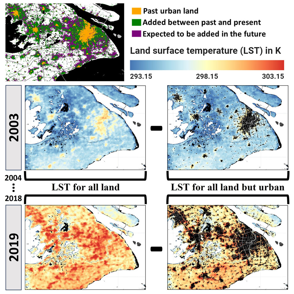
This graphic depicts the change in land surface temperature over Shanghai, China, and the surrounding area from 2003 to 2019. Much of the area has warmed.
This graphic depicts the change in land surface temperature over Shanghai, China, and its surroundings from 2003 to 2019. 
(Image courtesy of TC Chakraborty | Pacific Northwest National Laboratory)

For the most part, large-scale climate assessments have used surface air temperature readings from weather stations as inputs. However, such measurements are prone to sampling bias because surface instruments are often few and far between, only reading the conditions that immediately surround them.

“It is extremely difficult to capture the full heterogeneity of surface climate using these measurements,” said Chakraborty. “Though there have been huge efforts, through both new observation networks and better data assimilation techniques, that have made these estimates more and more reliable over time.”

To address the sampling issue, the authors of the new work instead used satellite-derived estimates of land surface temperature change. Satellite observations take in the bulk temperature of an area by measuring infrared radiation from every pixel of the Earth's surface, removing spatial sampling bias by design.

Researchers at PNNL are working to better incorporate urbanization into climate models, said coauthor and Lab Fellow Yun Qian.

“DOE has recently made significant investments in strengthening its leadership in climate modeling to drive research that can inform the development of resilience technologies to protect America’s diverse communities,” said Qian. “One of those major efforts is to improve urban representation in DOE’s flagship Energy Exascale Earth System Model. Seven national laboratories are collaborating in the E3SM project to develop the most comprehensive representation of the Earth system in a modeling framework and address the most challenging and demanding climate change research imperatives.”

This work was supported by the Department of Energy’s Office of Science.

###

About PNNL

Pacific Northwest National Laboratory draws on its distinguishing strengths in chemistry, Earth sciences, biology and data science to advance scientific knowledge and address challenges in sustainable energy and national security. Founded in 1965, PNNL is operated by Battelle for the Department of Energy’s Office of Science, which is the single largest supporter of basic research in the physical sciences in the United States. DOE’s Office of Science is working to address some of the most pressing challenges of our time. For more information, visit https://www.energy.gov/science/. For more information on PNNL, visit PNNL's News Center. Follow us on Twitter, Facebook, LinkedIn and Instagram.