Novel Field Campaign Sets Sail to Improve Offshore Wind Forecasts
PNNL leads groundbreaking project to increase certainty in offshore wind predictions, potentially saving millions of dollars
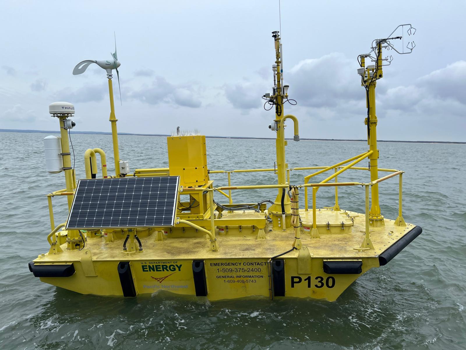
Pacific Northwest National Laboratory deployed a new flux sensor (instrument furthest to the right) in collaboration with University at Albany on a Department of Energy lidar buoy as part of the Wind Forecast Improvement Project 3.
(Photo by Matt Brooking | University at Albany)
The nation is closer to its offshore wind energy goals than ever before, but has some rough waters yet to navigate. To further reduce risk and costs associated with offshore wind development—and help assure future wind farms operate efficiently and reliably—better wind forecasting is needed. Weather patterns are difficult to predict offshore due to complex atmosphere-ocean interactions and a lack of observational data. To address this challenge, Pacific Northwest National Laboratory (PNNL) and collaborators are charting a new course with help from novel technology and measurement approaches.
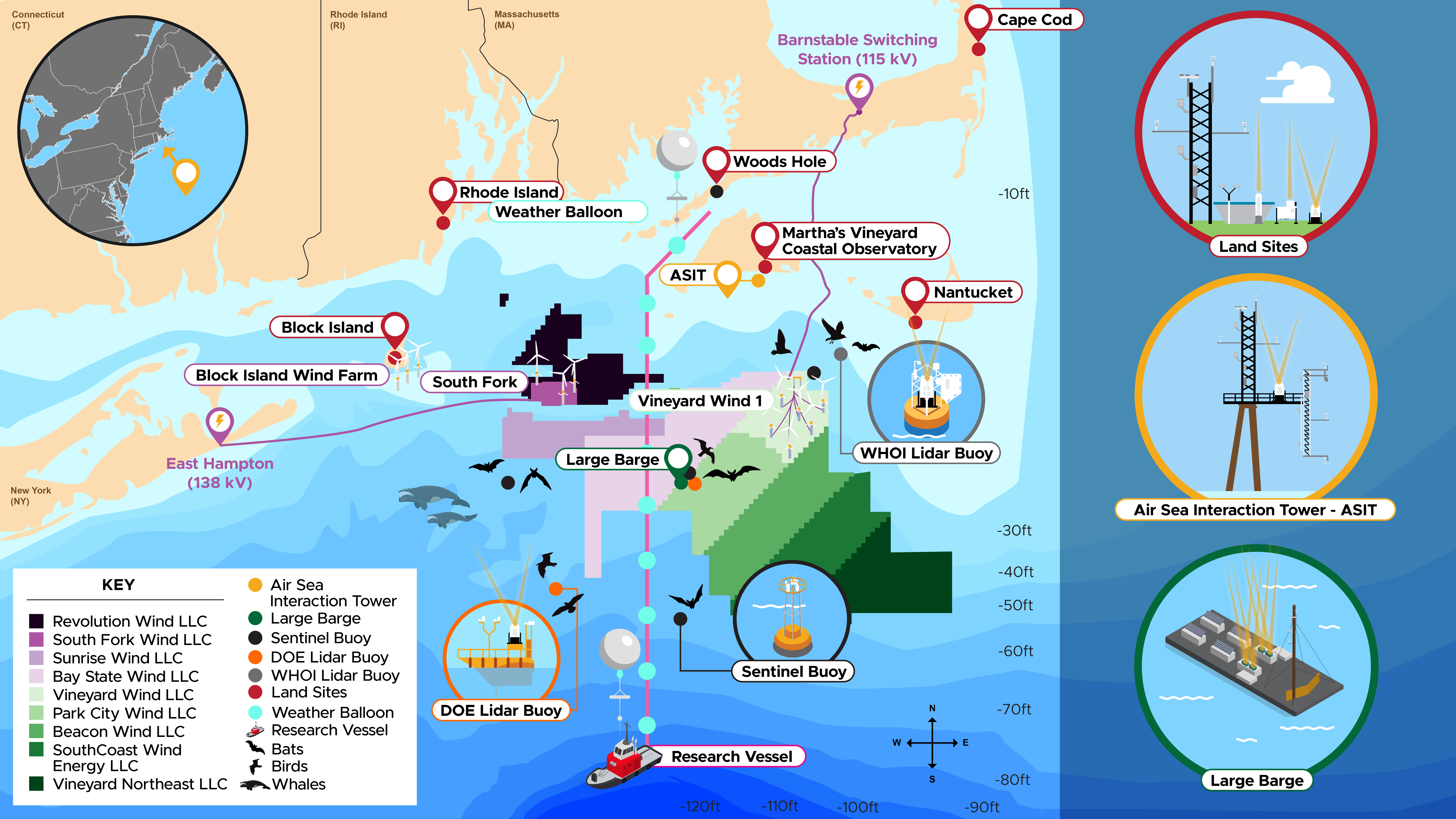
A new study represents the third stage of the Wind Forecast Improvement Project (WFIP3), supported by the Department of Energy (DOE) Wind Energy Technologies Office and co-led by PNNL, the National Oceanographic and Atmospheric Administration, and Woods Hole Oceanographic Institution. The overarching WFIP goal is to drive down the cost of wind-generated electricity with better data and improved forecasts, which has saved millions of dollars so far.
PNNL brings more than a decade of experience to this effort, having worked on WFIP since its inception in 2011 when it focused on the northern and southern Great Plains, followed by WFIP2, which tackled the terrain complexities of the Pacific Northwest. As the first offshore deployment project of the series, WFIP3 comes with a new set of challenges.
“Satellite data provide ground truth offshore, but don’t collect profiles of wind and temperature measurements at high temporal and spatial resolution needed for improving the accuracy of atmospheric models relevant to wind energy,” said Raghavendra Krishnamurthy, WFIP3 principal investigator and PNNL Earth scientist.
Therefore, field campaigns with ground-based instrumentation deployed over a large spatial region and spanning multiple seasons are essential for researchers to understand what improvements are needed to produce more accurate weather forecasts.
“Deploying atmospheric and oceanographic instruments offshore is challenging and requires attention to detail,” Krishnamurthy added. “It’s a much harsher environment for commercial instruments—and much harder to fix instruments offshore when they break. This has led to several new efforts in instrumentation and platform development currently being used in WFIP3.”
One such instrument is a novel atmospheric eddy-covariance flux sensor integrated on one of DOE’s PNNL-managed floating lidar buoys in collaboration with University at Albany. The atmosphere and ocean interact through air-sea fluxes, which drive general atmospheric circulations globally and provide information on how hub height atmospheric variability is influenced by the ocean (and vice versa). These unique measurements, along with vertical wind profiles from a Doppler lidar, will improve understanding of weather/resource variability and thereby improve forecasts. PNNL recently deployed one lidar buoy as part of WFIP3 and is scheduled to deploy another.
“Another part of WFIP3 we’re excited about is the deployment of a research barge in summer 2024,” Krishnamurthy said. “The lidar buoys have significant power limitations and can only house low-powered instruments. On the barge, we can have several cutting-edge powerful remote sensors that, for example, can accurately characterize the vertical structure of the atmosphere well above the turbine rotor layer. It will be one of the most novel things PNNL has been involved with in this area of research.”
The barge and several buoys will also be integrated with environmental sensors, such as PNNL’s ThermalTracker-3D, that will link atmospheric phenomena with migration and movements of wildlife surrounding the wind farms. This will help facilitate siting for future offshore wind turbines in the region.
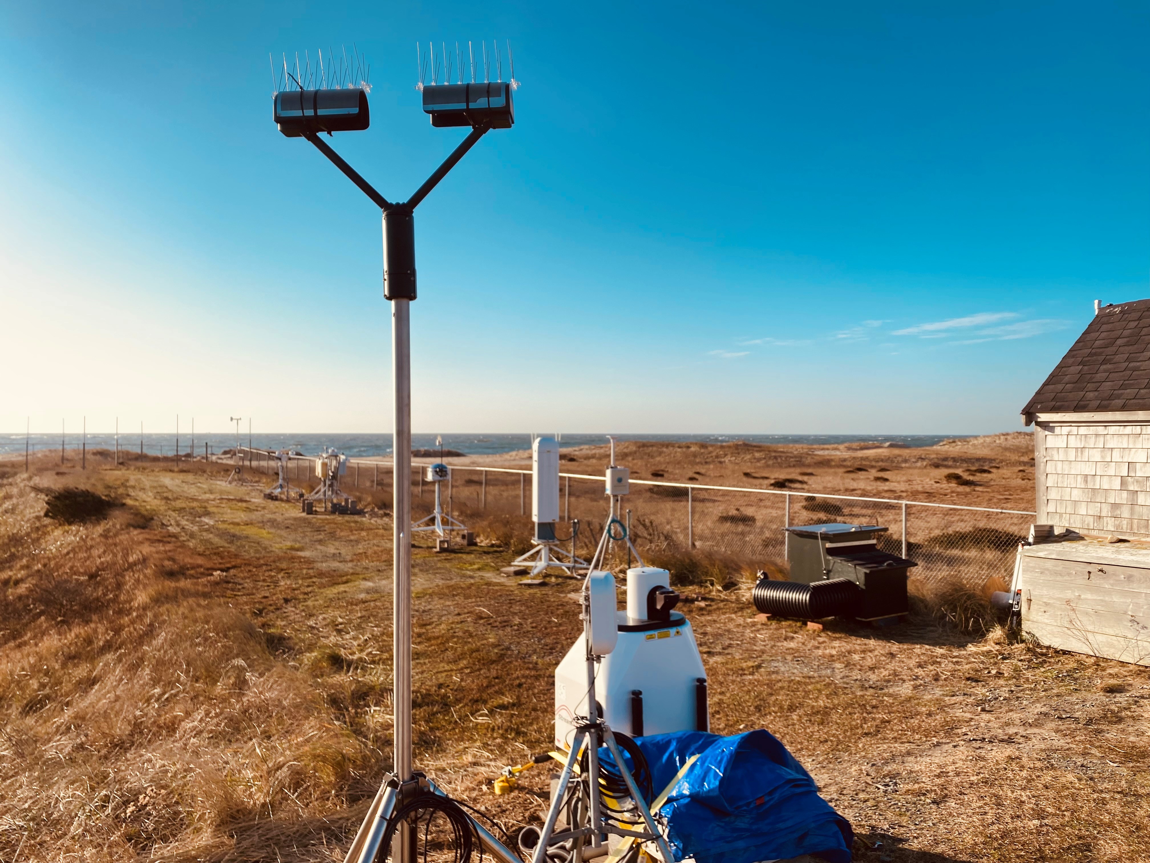
PNNL leads a group of DOE national laboratories and academic institutions under WFIP3 that has successfully deployed several remote sensing instruments, meteorological towers, and weather radars at nearby land sites—all of which will help improve understanding of local weather patterns and their impact on offshore wind farms. All data collected from the field campaign will be publicly accessible through the Wind Data hub, where PNNL will create and host real-time visualizations of the data.
WFIP3 is expected to result in extensive weather, oceanographic, and wildlife data, which will support responsible offshore wind siting, grid integration, and advancements in modeling and measurement technologies. The resulting scientific advancements will help validate standard industry models, thereby increasing certainty in wind resource characterization and lowering the cost of offshore wind development, benefitting both the industry and the public.
Read an update from DOE to learn more about WFIP3 and a recent PNNL story to learn more about the overarching WFIP effort. Stay tuned for more updates as this project develops.
Published: February 15, 2024