Modeling the Whole Earth
From model development to scientific discovery, researchers at PNNL play key roles in Earth system modeling

Researchers are adding to and testing the U.S. Department of Energy’s main Earth system model.
(Illustration by Cortland Johnson | Pacific Northwest National Laboratory)
The Earth system is massively complex. So is studying it. Researchers must balance the wide range of processes that happen across the Earth to develop a realistic, but reasonably affordable, method to model the Earth and how it behaves using computers.
Earth system models allow scientists to project changes in global weather patterns and study the interplay between different Earth system elements, like the water and atmosphere. This work is critical for accurately representing the climate and understanding the global interactions that affect it.
While multiple Earth system models currently exist, the Department of Energy (DOE) sponsors the Energy Exascale Earth System Model (E3SM) project. E3SM is a state-of-the-science Earth system model, continually refined by scientists across the United States.
Researchers at Pacific Northwest National Laboratory (PNNL) are working across the E3SM project. The team is adding new pieces to the model, improving what’s already there, and using E3SM to answer new scientific questions. PNNL Battelle fellow and Earth scientist Ruby Leung is the E3SM chief scientist guiding the overall scientific objectives and directions of the project.
“E3SM is a unique project aiming to leverage DOE’s next generation computers to better understand how Earth system processes behave and change,” said Leung. “Since 2014, researchers across the National Laboratory system have collaborated to develop a powerful model. Collaborating with team members across the project, PNNL scientists play key roles in developing and using E3SM.”
Projects related to E3SM generally involve either developing new capabilities for the model, testing the model’s performance, or using the model to answer important scientific questions through simulations. Scientists at PNNL do all three.
Developing new capabilities for the model
The first step in modeling anything is creating a practical and usable model. Even though E3SM has been in use since 2015, researchers are constantly adding new and more specific features to the model.
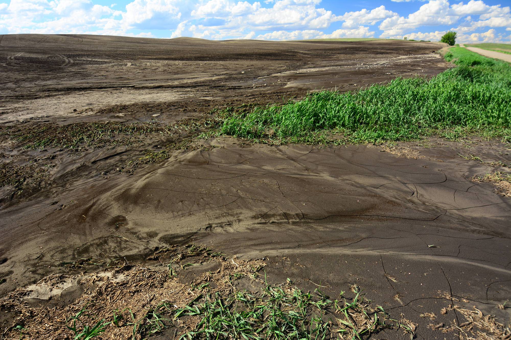
For example, soil erosion is an incredibly important part of how landscapes change, with implications for global agriculture and the carbon cycle. However, most Earth system models do not represent soil erosion. This limits their ability to project how changes in the climate or human behavior will alter the landscape and impact the Earth system.
Recently, scientists at PNNL developed a new model of soil erosion and sediment movement compatible with E3SM. To better represent how soil erosion will respond to changes in agricultural management, the model specifically accounts for practices like conservation agriculture and differences in irrigation. Agriculture is just one factor contributing to soil erosion, though.
The new model also looks at how different geological factors, like the presence of glaciers and the composition of local rocks, affect erosion. The model uses these processes to examine more than just erosion. It also looks at how soil moves throughout river systems as sediment, a crucial part of moving agriculturally necessary nutrients across space.
“Soil erosion is a critical process that drives carbon movement between the land and ocean,” said PNNL Earth scientist and lead author of the study Zeli Tan. “Better modeling soil erosion and river sediment motion is essential for studying river and coastal systems.”
The team compared their simulations to other, benchmark models. They found that the new model better predicts soil erosion in mountainous regions and represents the flow of soil sediment through river basins more accurately.
The model shows that conservation agriculture, common in the United States and Argentina, greatly reduces soil erosion. However, irrigation practices in many Asian countries have increased soil erosion. This initial work specifically focused on modeling soil erosion and sediment movement in isolation to test the model within the E3SM land component. The next phase involves testing the model in the fully coupled E3SM with interactive Earth system components. This should allow researchers to better understand how changes in climate will affect soil movement and how soil erosion may affect climate through its effects on the carbon cycle.
Testing, evaluating, and improving models
After initial model development, researchers have continued to test different parts of E3SM to identify areas for improvement. Inevitably, all models contain biases and errors that can make their predictions unrealistic. PNNL Earth scientist Po-Lun Ma worked to recalibrate the atmospheric component of E3SM. He and his collaborators found that the model’s representation of clouds had a major effect on the rest of the atmosphere.
Clouds are an incredibly important part of the atmosphere. They absorb and reflect sunlight, move moisture across spaces, and affect the circulation of air. However, representing clouds in atmospheric and climate models remains a major challenge.
“Clouds are one of the largest sources of uncertainty in climate models,” said Ma. “We know how important they are to the climate system, so we focus exclusively on clouds in this study.”
Climate models have consistently showed biases in modeling clouds, making their representation an area for improvement. Ma and his collaborators changed the model to better represent the behavior of clouds. They performed a calibration process in which model simulations of the current climate act as a base for comparing model projections for the future.
“During model calibration, everything is a trade-off,” said Ma. “The more accurately you represent one process, the more likely you are to be off somewhere else. This new work makes it easier to balance those trade-offs and find the best combination.”
The researchers found that better representing clouds led to less bias in other areas of the model. For example, the model more accurately projected the circulation of air throughout the atmosphere. A key component of the new calibration was treating regions and types of clouds differently, as they have different effects on energy and water. While this takes substantially more resources than assuming clouds are the same everywhere, it leads to a more accurate model.
Simulating regional rainfall
With a properly calibrated model, researchers can perform experiments to understand Earth system behavior. When large deviations from the normal conditions occur, such as unusually heavy rainfall in a region, model simulations can help researchers identify the underlying mechanisms of what’s happening.
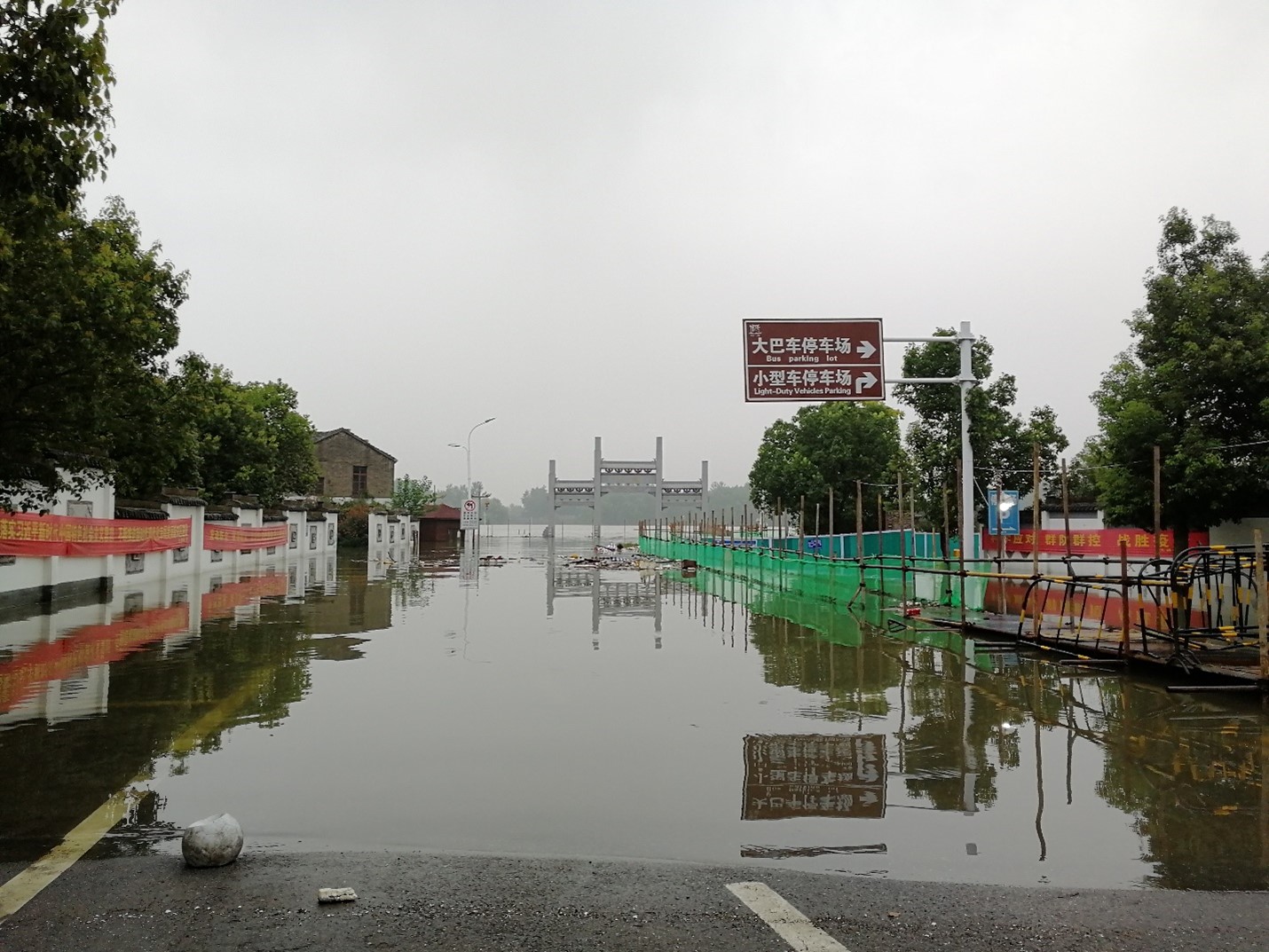
In a study published in Nature Communications, scientists at PNNL employed E3SM to understand the causes of the record high rainfall and severe flooding seen in eastern China during the summer of 2020. The research team thought that the reduction in aerosols, tiny particles suspended in the air, caused by shutdowns related to the COVID-19 pandemic might be a key factor.
“We know that higher amounts of aerosol may affect light rain and heavy rain differently,” said Leung. “We wanted to determine if there was a connection between the record high rainfall in eastern China and decreases in aerosol emissions.”
PNNL Earth scientist Hailong Wang, Leung, and a team of collaborators used E3SM to simulate the weather and climate under normal emissions and the substantially lower emissions during the pandemic. They found that the reduction in aerosols linked to the pandemic accounted for approximately a third of the increased rainfall in eastern China during the summer of 2020.
This type of extremely rapid emissions reduction is different than what researchers typically study. Emissions are much more likely to slowly decrease over time due to long-term changes in energy production technology or policy. “This type of dramatic emissions reduction event is unique in our modeling and evaluation,” said Wang.
Experiments showed that the dramatic reduction in aerosols affected how much moisture was delivered to certain parts of the atmosphere. A sustained increase in moisture over eastern China led to more rainfall, contributing to the summer 2020 flooding. This work highlights how changes in aerosols can alter weather and water extremes.
“Models like E3SM are essential for understanding how the Earth behaves and changes,” said Leung. “The work we do at PNNL moves our knowledge of the Earth system forward, allowing us to ask and answer new questions.”
This work was funded by the DOE, Office of Science, Biological and Environmental program.
Published: June 24, 2022