May 22, 2020
Feature

Connecting Coastal Processes with Global Systems

New review led by PNNL researchers recommends refining descriptions of coastal ecosystems in Earth system models.

ocean, beach and trees

Coastal interfaces are some of the most biologically and geochemically diverse ecosystems on the planet. Photo by Nathan Anderson on Unsplash.

We live, work, and play at the coast.

About 40 percent of the world’s population currently lives near the coast. Much of the world’s energy, defense, and industrial infrastructure is located on the coast, and shipping through coastal ports accounts for more than 90 percent of global trade.

But coastal landscapes are also vulnerable to global change. By 2100, more than twice as many people could live in areas susceptible to flooding, given sea level rise, urban growth, immigration, and high carbon dioxide emission scenarios.

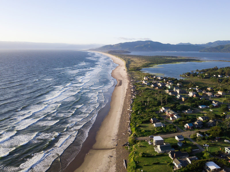
coastline with beach, trees and houses inland and mountains in the background
Coastal interfaces, where the land meets the sea, provide many societal and ecosystem benefits, such as tourism, trade, and nutrient exchange. Photo by Dan Meyers on Unsplash.

“The main global climate [computer] models researchers use currently describe the coast as a pixel that is essentially half land and half ocean,” said PNNL biogeochemist Nick Ward. “It just hands off the land to the sea.”

In a recent review article, published May 18 in Nature Communications, an interdisciplinary team of researchers led by Ward proposed a path to refining the representation of coastal interfaces in Earth systems models used to predict the climate on Earth. They suggest describing the functions of coastal interfaces on an ecosystem scale, classifying coastal ecosystems into a few functional types, using detailed models that exist at local scales for those categories, and then applying lessons learned from local models to similar coastal ecosystems around the entire globe.

Defining coastal process gradients on an ecosystem scale

Earth system models describe how ecosystems around the world interact through nutrient and energy transfer to influence climate. Biological and geochemical diversity are the foundation of many of those transfer cycles, and coastal ecosystems are home to some of the most biologically and geochemically diverse systems on the planet.

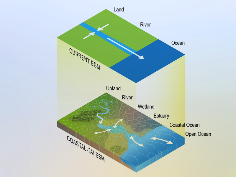
However, most details about the function of coastal ecosystems is missing from current Earth system models. These models currently represent a coastal interface as a simple transition between land and sea. In reality, the interface is a gradual shift, shaped largely by the balance between tidal flow and freshwater discharge from land.

illustration of how computer climate models represent the land and ocean interface simply
Current Earth system models (ESM) represent the land-sea interface simply. A new review article led by a PNNL researcher proposes a more refined representation that reflects the gradual transition from land to sea at coastal interfaces. Illustration by Nathan Johnson | PNNL.

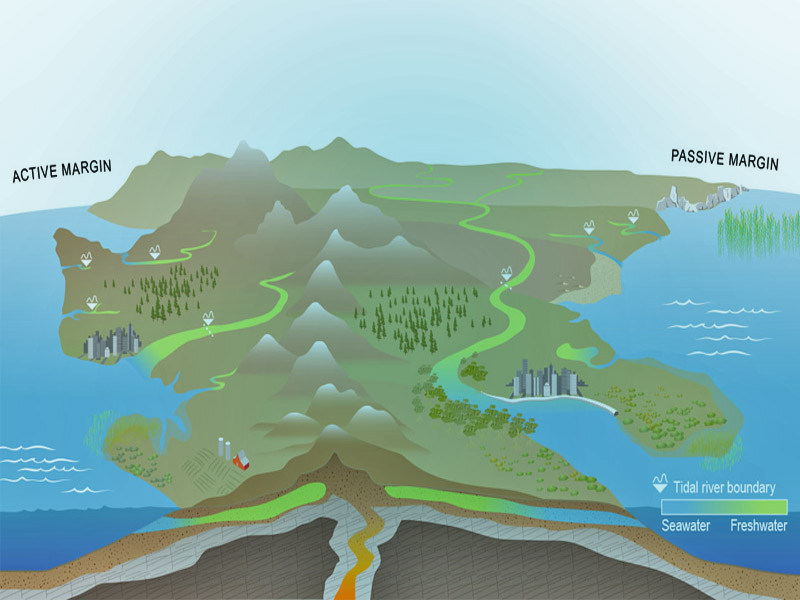
Geography—steep or shallow coastlines—is a primary factor that influences how freshwater and seawater interact at a coastal interface. The effect of tides travels further inland through tidal rivers for shallower coastlines than one where rocky cliffs meet the sea. Also, following the flow of water at a coastal interface reveals processes and gradients from the scale of molecules and microbes to trees and sediment.  

The mix of freshwater and saltwater at a coastal interface generates a salinity gradient that influences the types of plants that grow inland as well as the composition of microbial communities living in the soil and sediment. The plants and microbes in a coastal area affect the nutrient and carbon cycles of an ecosystem, and sediment washed from land into rivers and estuaries influences the nutrient availability.

“These factors have been studied in labs and at different sites around the world,” said Vanessa Bailey, a soil scientist at PNNL. “Now we want to bring together everyone studying the interface between land and the sea to better understand the connected processes happening in coastal interfaces on the ecosystem scale.”

illustration of how freshwater and saltwater mix at coastal interfaces depending on geography
The geography of a coastline—a steep active margin or a shallow passive margin—affects how freshwater and seawater mix at a coastal interface. Illustration by Nathan Johnson | PNNL.

Describing coastal process disruption and resilience

As scientists work to better understand how coastal ecosystems function, they also have a second task: to study how resilient these ecosystems are to global change. Because coastal ecosystems are an interface between land and sea, they also experience effects from disruptions in both areas. Drought and land use changes inland can affect coastal processes, along with sea level rise in the ocean.

With so many interconnected processes happening in coastal ecosystems, scientists face many questions when creating detailed predictive models of the function and response of coastal interfaces. Which coastal processes and which land-based processes need to be included? On what geographic and time scales? Do the models reflect how coastal ecosystems could respond to global change?

Classifying coastal processes and coordinating future research

In their article, the team of interdisciplinary researchers from academia, national laboratories, and federal agencies proposes a strategy to answer those questions. One way to represent coastal interfaces in Earth system model is with a model of every coastal ecosystem in the world. However, with 372,000 miles of coastline around the world, the researchers acknowledge that task is unfeasible.

So they offer another option: classify coastal ecosystems into a few functional types, make detailed models for those categories, and then apply those models to other coastal ecosystems.

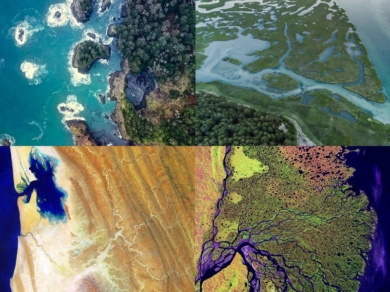
collage of different coastal systems
Coastal ecosystems look very different around the world, but they could have common features that are useful to describe in detail for Earth system models. Photos by USGS, Cameron Venti, and Nathan Anderson on Unsplash.

Functional classifications could describe geographic features, like rugged coastlines or gently sloping beaches. They could describe ecosystems in ways that gather different types of estuary systems, tidal flats, or shorelines together.  

“As the scientific community develops these models, it will also reveal gaps where more observational data are needed to validate the models,” Ward said. To gather that data, he and his colleagues recommend leveraging existing long-term ecological monitoring networks and directing the research toward common questions.

The task ahead is something no one can do alone, the team concluded. Ward agreed: “Developing these detailed models will require coordination across institutions, funding agencies, and existing long-term research networks to develop a global-scale understanding of coastal interfaces.”

The PNNL Laboratory Directed Research and Development program funded this work as part of the Predicting Ecosystem Resilience through Multiscale Integrative Science (PREMIS) Initiative.

###

About PNNL

Pacific Northwest National Laboratory draws on its distinguishing strengths in chemistry, Earth sciences, biology and data science to advance scientific knowledge and address challenges in sustainable energy and national security. Founded in 1965, PNNL is operated by Battelle for the Department of Energy’s Office of Science, which is the single largest supporter of basic research in the physical sciences in the United States. DOE’s Office of Science is working to address some of the most pressing challenges of our time. For more information, visit https://energy.gov/science. For more information on PNNL, visit PNNL's News Center. Follow us on Twitter, Facebook, LinkedIn and Instagram.
Published: May 22, 2020