January 30, 2024
Research Highlight

Detecting Atmospheric Rivers with Satellite Observations

A novel method includes new algorithm to glean important information about atmospheric rivers from satellite observations

Atmospheric Rivers show via satellite

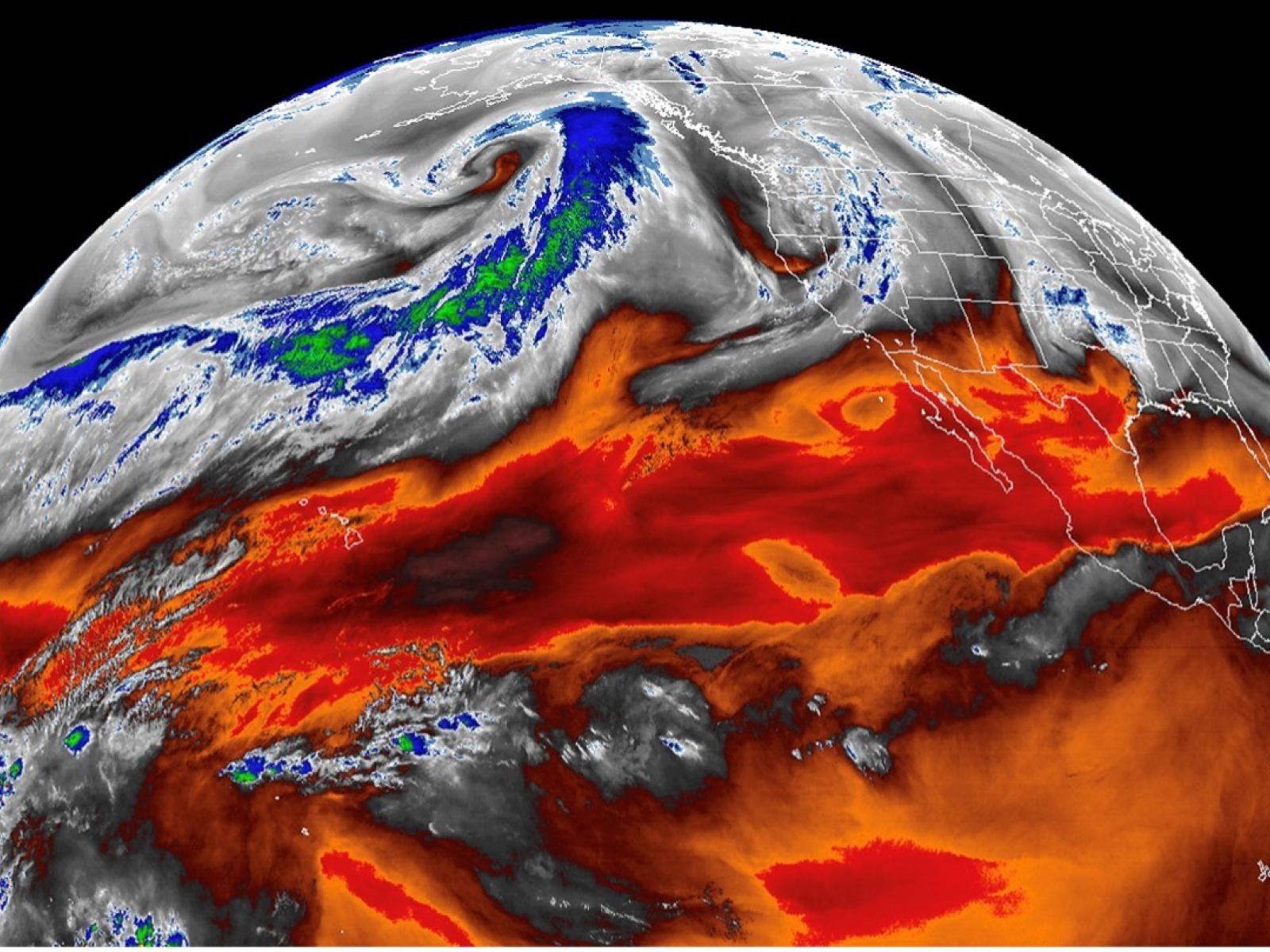
Atmospheric rivers, filaments of intense moisture transport in the atmosphere, can now be automatically detected in satellite observations.

Image: NOAA

The Science                                 

Atmospheric rivers (ARs) are filaments of intense moisture transport in the atmosphere. These weather systems drive a large fraction of the extreme precipitation events over coastal regions. Detecting ARs in satellite observations has long been a challenging task due to the lack of wind information. In new research, scientists derived an approximation of the 3-dimensional (3-D) wind field based on the spatial distribution of the satellite-based temperature. Combining this approximated 3-D data with the moisture observed by satellite, scientists created—for the first time—a method to detect ARs via satellite observations. Using this newly developed method, scientists produced the first satellite-based near-global AR dataset.

The Impact

Scientists have long since detected ARs using data from numerical model simulations. The use of satellite observations would have given them a real-time, global view of ARs solely based on observations, which was more desirable, but such information was out of reach due to the lack of matching wind data.

Now, using a novel method to approximate the 3-D wind data via satellites, scientists can automatically detect ARs using satellite observations, and they’ve produced a benchmark AR dataset for nearly the entire globe. Additionally, their evaluation of existing AR data shows that reanalyses overestimate the frequency of precipitation produced in ARs but underestimate its intensity.

Summary

ARs are filaments of intense horizontal moisture transport in the atmosphere. They’re responsible for most of the poleward atmospheric moisture transport over mid-latitudes and are very effective in driving extreme precipitation. Historically, analyses and predictions of ARs were done using products from numerical models that could only consider incomplete information from satellite, radiosonde, and ground-based observations as input. Furthermore, existing satellite-based AR detection algorithms were essentially only on regional scales. For years it was the best observational-based information scientists had as they attempted to track and predict such extreme weather events.

In a new study, scientists developed a near-global AR detection algorithm that incorporates 3-D wind information from satellite observations, providing a much more accurate picture of impending extreme weather events around the world. The new algorithm combines both the moisture field and wind information, namely two key factors defining AR, from satellites. Scientists used the new detection method to create the first satellite-based near-global AR dataset. Using this new dataset as a benchmark, scientists are learning the shortfalls of previous AR analyses, such as width of the ARs, and they said the findings can help improve the representation of ARs and associated precipitation in reanalyses and climate models. As the quality of satellite observations continues to improve, the methodology presented here can be applied to other satellite observations to develop higher resolution or higher frequency AR statistics.

PNNL Contact

Hailong Wang
hailong.wang@pnnl.gov

Funding

This research has been supported by the Department of Energy Office of Science Regional and Global Model Analysis program area as part of the HiLAT-RASM project.

Published: January 30, 2024

Ma, W., G. Chen, B. Guan, C. A. Shields, B. Tian, and E. Yanez. 2023. “Evaluating the representations of atmospheric rivers and their associated precipitation in reanalyses with satellite observations.” Journal of Geophysical Research: Atmospheres, 128, e2023JD038937. https://doi.org/10.1029/2023JD038937