Calibration and Uncertainty Analysis of Demeter for Better Downscaling of Global Land Use and Land Cover Projections
Researchers improved the Demeter model’s performance by calibrating key parameters and establishing important workflows

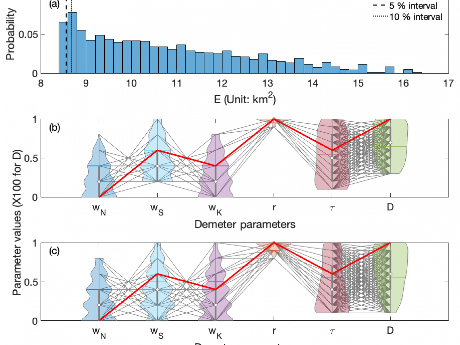
This chart summarizes the new calibration and uncertainty quantification workflows in the Demeter model. A synthesized land cover change record was created at a subregional scale (i.e., the same spatial scale as GCAM) based on the Land Cover project of the European Space Agency Climate Change Initiative (CCI-LC) data at a higher spatial resolution (0.25 degree). The CCI-LC data were used as the benchmark against the Demeter-downscaled land cover at 0.25-degree resolution driven by an ensemble of parameters sampled in their possible ranges. With this approach, users can identify a subset of parameter sets leading to the fewest mismatches between the downscaled product and the benchmark. They also can quantify the sensitivity of Demeter-downscaled land cover distributions to parameters.
The Science
The Demeter model effectively translates regional projections of future land use and land cover from integrated human-Earth system models into high-resolution representations that can be used in a variety of Earth system and hydrologic models. Demeter also acts as an important link between models of human and natural Earth systems as it resolves the scale mismatch of land cover change in these models. Initially, Demeter was not thoroughly calibrated, leading to differences from observations in the land use and maps it generated. Researchers at the U.S. Department of Energy’s Pacific Northwest National Laboratory (PNNL) conducted rigorous sensitivity analysis, parameter calibration, and uncertainty analysis of Demeter, using a long-term, global satellite-based land cover record. The research team improved Demeter’s performance and developed references for proper use of the model as well as a sound approach to understand Demeter’s results and uncertainties.
The Impact
The calibration and uncertainty analysis in this work are critical for integration of human and natural system models at multiple scales. The calibrated Demeter parameters and the workflow developed for calibration are key user references for parameter selection and uncertainty quantification and will ultimately help reduce the uncertainty in simulated water availability and irrigation water demand from downstream hydrology and Earth system models.
Summary
Demeter is an open-source spatial downscaling model that disaggregates land use projections from integrated human-Earth system models, such as the Global Change Assessment Model (GCAM). Demeter has become a key element in GCAM’s modeling ecosystem, and it also serves as a critical link between human and natural systems in modeling multisector dynamics. However, an uncertainty quantification workflow for Demeter was not established initially. Also, the model’s sensitivity to key parameters (e.g., the weights of spatial constraints, the ratio of land cover intensification, and the threshold for selecting pixels for land cover expansion) was unknown. In this work, researchers rigorously tested Demeter’s parameter sensitivities. They also calibrated key parameters by minimizing the mismatch between model-downscaled and satellite-observed land use and land cover change in the past two decades. To calibrate the parameters, they used a long-term, global satellite-based land cover record from the Land Cover project of the European Space Agency Climate Change Initiative (CCI-LC). Researchers established calibration and uncertainty quantification workflows, which can be used to refine Demeter applications in specific regions when additional observational data sets become available.
The results identified the optimal parameter values for Demeter’s global applications and showed that the calibration substantially improved the model’s performance when compared to the satellite observational records. The most sensitive parameters were the ratio of land cover intensification and the threshold for land cover expansion. These parameters need to be carefully tuned, especially for future regional applications. Posterior parameter uncertainties can be important when they are propagated into downstream simulations. This suggests that to better account for the uncertainties in Demeter-downscaled land cover products, a parameter ensemble should be used rather than a single “best” parameter set. This study provides a key reference for Demeter users and is expected to help reduce uncertainties in downstream hydrologic and Earth system simulations.
Funding
This research was supported by the U.S. Department of Energy, Office of Science, as part of research in the MultiSector Dynamics, Earth and Environmental System Modeling program.
Contacts
Published: July 21, 2020
Chen M, CR Vernon, M Huang, KV Calvin, and IP Kraucunas. 2019. “Calibration and analysis of the uncertainty in downscaling global land use and land cover projections from GCAM using Demeter (v1.0.0).” Geoscientific Model Development 12:1753‒1764, https://doi.org/10.5194/gmd-12-1753-2019.