SSM Habitat Restoration: Port Susan Bay
The Nature Conservancy, October 2005 - 2006

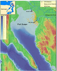
Port Susan Bay is located in Puget Sound's Whidbey Basin, which receives freshwater flows from the Stillaguamish River in northern Snohomish County, Washington. It is bounded by Camano Island on the west and north, and the Snohomish County shoreline on the east. The Stillaguamish River is an important estuary for salmon migration and many wildlife species. The Nature Conservancy (TNC) owns substantial acreage along the northeast shoreline of Hat Slough. The property is currently confined by surrounding dikes and is disconnected from the tidal functions near the river mouth. TNC is currently planning to restore this region to its natural tidal wetlands condition to improve tidal exchange and increase marine wildlife productivity by partially or completely removing the 2240-m dikes around the property.
Battelle's modeling team supported TNC in developing a comprehensive numerical modeling tool to evaluate different restoration alternatives and provide guidance in the restoration design. The restoration approach is based on different dike removal configurations for the TNC-owned existing dikes along the shoreline north of Hat Slough. In this study, a high-resolution three-dimensional estuarine and coastal circulation model (Finite Volume Coastal Ocean Model) was developed to cover the entire Port Susan Bay from Camano Head at the south to West Pass at the north. The hydrodynamic model was calibrated using field-measured tidal elevation, velocity, and salinity data collected from the study area. The calibrated model was applied to simulate different restoration alternative conditions. Model results between existing condition and different alternative conditions will be compared to identify the optimal alternative for achieving the maximum restoration benefit.

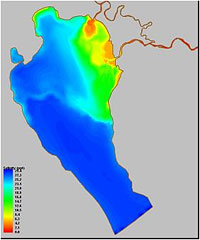
distribution during ebb
Project Highlights
- A high-resolution model grid was developed to represent multiple tidal channels in the mud flat region to accurately simulate salt intrusion in the estuarine system.
- Tidal inundation in the large tidal flats region in the bay and estuary mouth was successfully simulated using the wetting/drying feature of the model.
- Model results indicated that high variations in salinity and strong freshwater fronts exist in the Stillaguamish River estuary.
- The model developed will be used to assess the feasibility of restoring tidal functions through the proposed dike modification alternatives and help guide future actions.
Contacts and Project Team
- PNNL: Tarang Khangaonkar (CO-PI), Zhaoqing Yang (CO-PI), Ron Thom (PI), Kathryn Sobocinski (CO-PI)
- The Nature Conservancy: Roger Fuller
Study Reports and Publications
Yang Z,. KL Sobocinski, A Borde, T Khangaonkar, and R Thom. 2006. Hydrodynamic and Ecological Assessment for Port Susan Bay Restoration Project. Battelle PNWD-3674, prepared for The Nature Conservancy, by Battelle, Pacific Northwest Division, Richland, WA.
Yang Z, K Sobocinski, D Heatwole, T Khangaonkar, R Thom, and R Fuller. 2010. Hydrodynamic and ecological assessment of nearshore restoration: A modeling study. Ecological Modelling, 221(7):1043-1053. doi: 10.1016/j.ecolmodel.2009.07.011.