Key to Understanding How Watersheds Function Lies in the Sediment
Researchers categorized and mapped riverbed sediments along the Columbia River to understand sediment impacts on water exchange and chemical activity

The Science
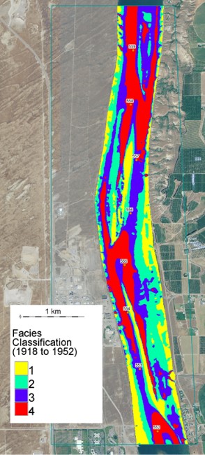
Co-authors of a paper in Hydrological Processes led by PNNL researchers Zhangshuan Hou, Timothy Scheibe, and Christopher Murray, produced a map that identifies different classes of sediments which compose the riverbed along the Hanford Reach of the Columbia River. These sediment classes, called facies, have distinct textures that play important roles in surface water/groundwater exchanges and biogeochemical activity.
The Impact
The riverbed sediments along the Hanford Reach of the Columbia River are strongly heterogeneous, making it challenging to incorporate their complexity in predictive models. This research categorized the sediments into classes facies to reduce the complexity of the heterogeneous system to classes with distinct sediment texture that correspond to variations in hydrologic properties. The riverine facies enable more accurate modeling of hydrologic exchange flows and biogeochemical processes.
Summary
In the Hanford Reach of the Columbia River, the texture of sediments on the riverbed have a strong influence on the exchange of groundwater and surface water and is associated with elevated levels of biogeochemical activity. This layer of sediments is strongly heterogeneous, making it a challenge to model, for example, the environmental impact of increased river flows.
To overcome this type of challenge in aquifers, researchers often turn to facies, a sediment classification scheme that groups complex geologic materials into a set of discrete classes according to distinguishing features and can be used to assign heterogenous material properties to grid cells of numerical models.
The usefulness of the facies approach, however, hinges on the ability to relate facies to quantitative properties needed for flow and reactive transport modeling. Previous research has shown that the grain size distribution of sediments in the riverbed is associated with properties of interest to the exchange of groundwater and surface water and related biogeochemical activity. Direct observational data on grain size distribution in the Hanford Reach of the Columbia River, however, is limited to selected locations with inadequate spatial coverage and resolution.
Therefore, to map facies in the Hanford Reach of the Columbia River, the authors integrated high-resolution observations such as the river geomorphology, depth, slope and signs of erosion with numerical simulations of historical river flows such as floods that are known to shape sediment texture by washing rocks and pebbles downstream. The team used machine learning models to determine which factors have the best correspondence with distinct distributions of sediment texture, creating a facies map with four classes of sediment textures that correspond to variations in hydrologic properties.
The authors say that the identification and mapping of facies in the Hanford Reach of the Columbia River will enable more accurate modeling of the system behavior, leading to more robust predictions, for example, of the fate and migration of groundwater contaminant plumes from nuclear waste materials produced and stored at the Hanford Site during the Cold War era as well as recent agricultural practices.
Contact
Zhangshuan Hou, Pacific Northwest National Laboratory, Zhangshuan.Hou@pnnl.gov
Funding
Funding for this research came from DOE Office of Science BER, PNNL Subsurface Biogeochemical Research SFA.
Revised: September 6, 2019 | Published: September 9, 2019
Hou, Z., Scheibe, TD, Murray, CJ, et al. Identification and mapping of riverbed sediment facies in the Columbia River through integration of field observations and numerical simulations. Hydrological Processes. 2019; 33: 1245–1259.