
Atmospher Sci & Global Chg
Research Highlights
June 2017
Let the River Go—and Overflow
Researchers refine a method to represent floodplain inundation in Earth system models
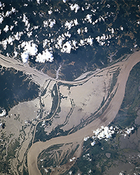
Inundated floodplains, such as these from a satellite view, adjacent to the lower Amazon River in June 1996, can have an impact on regional water and biogeochemical cycles. Photo courtesy of Earth Science and Remote Sensing Unit, NASA Johnson Space Center.
When heavy rain hits the lowlands, people may run for the hills. It can be hard to predict where and how much water will flow, or how it will settle—when rivers overflow their banks.
To better understand this floodplain inundation phenomena, Pacific Northwest National Laboratory scientists and colleagues extended the Model for Scale Adaptive River Transport (MOSART), a key component of the Department of Energy's Accelerated Climate Modeling for Energy (ACME) Earth system model. Researchers tested the extended model and saw improved modeling of land-surface hydrology in South America's Amazon River basin, where seasonal floods happen every year. The model improvement will help understand how inundation impacts the regional water and biogeochemical cycles.
Why It Matters: Water from heavy rainfall and rapid snowmelt can hurtle downhill and right into rivers that spill over their banks. When land no longer absorbs the excess water, flooding occurs, which could affect infrastructure and livelihoods. Meanwhile, water in the floodplain alters the exchange of water and energy with the atmosphere and soil that head downriver influence the water and nutrient cycles.
River inundation has extraordinary effects on land surface-groundwater interactions and aquatic ecosystems, as well. These changes alter how soils store water, which in turn could affect soil moisture and water availability. River inundation can also influence what flows into the ocean. This research provides an important foundation for predicting the impacts of global change on water resources and flood hazards by using Earth system models.
Methods: PNNL researchers and colleagues put into action a method to represent floodplain inundation in a river transport model. They refined the method to account for land-surface factors, which improved modeling of streamflow and inundation extent.
Scientists implemented and integrated a macroscale inundation formulation with the MOSART surface-water transport model, named MOSART-Inundation. When rivers overflowed their banks in the model, the inundation formulation estimated the amount of the river-floodplain water exchange, as well as the flooded area within each computational unit (a subbasin or model grid cell). Researchers tested the MOSART-Inundation model in the Amazon basin, which accounts for about 18 percent of the total continental freshwater flowing to oceans.
This research addressed several long-standing challenges in continental-scale modeling of surface hydrology by:
- Correcting the vegetation-induced offsets in surface elevation from observations in digital elevation model data
- Improving the approach for estimating channel cross-sectional geometry to better represent spatial variability in channel geometry
- Accounting for how riverbed resistance to river ?ow varies with the river size
- Considering backwater effects to improve simulation of river flow in gentle-slope reaches.
Researchers evaluated the model's performance using streamflow records from stream gauges, altitude measurement data from the Envisat satellite, and "Global Inundation Extent from Multi-Satellites" (GIEMS), a unique dataset offering surface water extent and dynamics with a long-time record (1993-2007), most of them derived from satellite observations.
Finally, their sensitivity study showed that representing floodplain inundation, as well as refining floodplain topography, channel geometry, and river flow formulations, could significantly improve surface water dynamics modeling results in the Amazon basin.
What's Next? Researchers will incorporate the inundation formulation into the ACME model. They will then evaluate the method at the global scale and use simulations to improve understanding of river-land interactions and feedbacks to the atmosphere.
Acknowledgments
Sponsor: The U.S. Department of Energy Office of Science, Biological and Environmental Research supported this research as part of the Earth System Modeling program through the Accelerated Climate Modeling for Energy (ACME) project.
Research Team: Xiangyu Luo, L. Ruby Leung, and Teklu K. Tesfa, PNNL; Hong-Yi Li, PNNL and Montana State University; Augusto Getirana, NASA Goddard Space Flight Center; Fabrice Papa, LEGOS/IRD and Indo-French Cell for Water Sciences; and Laura L. Hess, University of California, Santa Barbara
Research Area: Climate and Earth Systems Science
Reference: Luo X, H-Y Li, LR Leung, TK Tesfa, A Getirana, F Papa, LL Hess. 2017. "Modeling Surface Water Dynamics in the Amazon Basin Using MOSART-Inundation v1.0: Impacts of Geomorphological Parameters and River Flow Representation." Geoscientific Model Development 10:1233-1259. DOI: 10.5194/gmd-10-1233-2017