
Atmospher Sci & Global Chg
Research Highlights
October 2014
Fast and Rigorous: Finding Surface Reflectivity by Looking Up at Clouds
New method efficiently estimates surface reflectivity from incoming sunlight bounced back by clouds
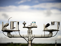
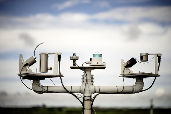
The Dual Multifilter Rotating Shadowband Radiometer takes spectral measurements of direct, diffuse, and total horizontal solar irradiances. Instruments such as these, located at the Southern Great Plains site in Oklahoma help scientists understand the amount and type of light that hits Earth’s surface. Photo courtesy of the ARM Climate Research Facility. Enlarge Image.
Results: Capturing sunlight reflected off the Earth's surface and bounced off a cloud back to the Earth is an effective measure of surface reflectivity—or surface albedo, the measure of how mirror-like the Earth's surface is. Researchers at Pacific Northwest National Laboratory developed a new way to measure surface albedo by capturing that cloud-bounced sunlight. In collaboration with scientists from the National Oceanic and Atmospheric Administration (NOAA) and University of Colorado, the researchers showed how the method has potential for capturing the surface albedo operationally and with accuracy.
"Previously, retrieving surface albedo from incoming sunlight measurements required substantial computational power and complementary information on cloud and atmospheric properties, which is often limited or unavailable," said Dr. Evgueni Kassianov, PNNL atmospheric scientist and lead author of the paper, which appears in the journal Atmosphere. "Our method is based on a one-line equation and is simple, fast, and requires only a few inputs."
Why It Matters: Understanding climate change begins with measuring basic and important energy factors affecting the Earth. Scientists must understand the amount of sunlight coming in and going out, and a key component of that calculation is how much sunlight gets "bounced around" after it hits the Earth.
Scientists have installed conventional tower-based instruments but these are limited to several well-established sites. Moreover, tower installations are expensive and more important, instruments mounted on towers can only measure the reflectivity directly under that tower. These local measurements may not represent a larger area, something that is of most significance for climate studies.
In contrast to the towers, instruments that look up toward the sky—used to measure incoming sunlight energy—are deployed at many more diverse locations with differing surface properties. The new method described in this paper can calculate the areal-average surface albedo—that is, a larger surface area—at these locations. This measurement is exactly what is needed to validate and improve large-scale models.
Methods: The PNNL research team, with their NOAA and University of Colorado collaborators, demonstrated the feasibility of this new method for retrieving areal-average spectral surface albedo for different landscapes. They applied their method using integrated datasets from a two-month (April-May, 2010) and a five-year (2008-2013) period at the NOAA Table Mountain and ARM Southern Great Plains sites, respectively. To validate the method, these datasets combined data from 1) upward-looking instruments, 2) tower-mounted instruments, and 3) satellites. The scientists demonstrated good agreement between albedos derived from this method, and albedos from satellites. Tower-based albedos also compared favorably with the albedos obtained from this method, when the tower albedos were thought to be representative of large areas surrounding the towers.
"We expect our method will be applied at many climate-important locations because of its appealing operational possibilities and the abundance of upward-looking instruments at these sites for measuring the incoming sunlight," said Kassianov.
What's Next? The team plans to extend the new method to hyperspectral ground-based instruments for improved estimations of spectral surface albedo over a wide wavelength range.
Acknowledgments
Sponsor: This research was funded by the U.S. Department of Energy Office of Science, Office of Biological and Environmental Research, Atmospheric Radiation Measurement (ARM) Climate Research Facility.
Research Team: Evgueni Kassianov, James Barnard, Connor Flynn, and Laura Riihimaki at Pacific Northwest National Laboratory; Joseph Michalsky at NOAA, Earth System Research Laboratory; and Gary Hodges at the University of Colorado.
Research Area: Climate & Earth Systems Science
Reference: Kassianov E, J Barnard, C Flynn, L Riihimaki, J Michalsky and G Hodges. 2014. "Areal-Averaged Spectral Surface Albedo from Ground-Based Transmission Data Alone: Toward an Operational Retrieval." Atmosphere 5: 597-621. DOI: 10.3390/atmos5030597.