
Atmospher Sci & Global Chg
Research Highlights
January 2012
Case Closed on Nauru Island
Scientists capture, tag, archive clouds' effect in tropics
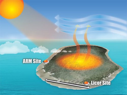
The sun's energy heats the interior of Nauru Island, causing low, small clouds that form "streets" moving in a trail off the island. When the breezes blow from the east, these small clouds blow over the ARM site on the western side of the island. Even with such a small land area, the island effect at times has a measurable and important influence on atmospheric data collected at the ARM site on the western edge of the island. Scientists have captured that difference and made the archived data more useful for past and future climate studies. Enlarge Image
Results: Tropical islands can charm. But scientists at Pacific Northwest National Laboratory detected something more than charm on Nauru Island. The team collared the cause of low clouds that trail off the island and disturb atmospheric measurements when the easterly breezes blow. These "cloud streets" affect those measurements for 11 percent of the daylight hours. With five years of data collected at the Atmospheric Radiation Measurement Climate Research Facility on Nauru, their analysis means past and future data from this site are more useful.
Why It Matters: At the birth center for climate forces that affect weather around the globe, scientists found new information that increases the usefulness of climate measurements. Convening on Nauru Island, two of these climate phenomena, El Niño and counterpart La Niña, affect floods and droughts around the globe. So, having specific and accurate climate measurements in this area would have big impacts. Collecting climate data on tiny Nauru has other advantages. With very little land area to soak up the sun, the ARM site measurements gathered here were expected to emulate the larger ocean area. Turns out, the island's central land area soaks up just enough heat to cause effects on the site's climate measurements under certain conditions. Making these climate measurements more meaningful may well, in the long run, mean a lot to someone planting rice on the other side of the world.
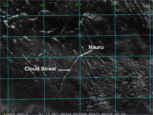
Produced by gently rotating “rolls” of air produced from surface heating over the island, the line of cumulus cloud streets are barely visible on satellite images of Nauru. These cloud streets can extend hundreds of kilometers southwest of the island and are evidence of the Nauru island effect. Image: Geostationary Meteorological Satellite at 1-kilometer from December 13, 2000.
Methods:
Cloud Streets. Scientists use atmospheric instruments to measure incoming sunlight energy, outgoing reflected energy, and how clouds affect both of them. Collecting this data at the ARM Tropical Western Pacific site located on the western edge of Nauru Island, scientists expected to get measurements that represented the greater ocean area. Instead, they noticed low, small clouds on the top of the boundary layer, which by end of day were organized into trails up to 200 km long, hanging off the island's west end. These "cloud streets" are not a new phenomenon, just unexpected at this location. The scientists wondered whether these clouds were a result of measurable conditions, and whether they skewed atmospheric measurements on the island.
Pinpointing the Effect. After identifying specific conditions as the Nauru Island effect in 1999 (McFarlane, et al.) the team put instrumentation in place to detect and measure the effect. With instruments in two locations on the island, the team was able to measure the variability of the data, depending on the wind direction, during five years of data sets. When winds originated from the east, they concluded that the Nauru effect is a daylight phenomenon, increasing clouds by 15-20 percent when clouds occur and reducing incoming sunlight energy 17 percent of that time. Over a 24-hour period, these numbers decrease. But for short-term atmospheric measurements of incoming sunlight energy, or those that separate data by the amount of air movement forming clouds, the effect may have a big impact. Wind direction is also key as the effect is only active when winds come out of the east. For studies using data for long-term averages, or climate modeling, the 2 percent average increase in low-level clouds with decreased sunlight energy caused by the Nauru effect will not be consequential.
"We put the instruments in place to use the methodology, so that we can tell on a minute-by-minute basis when the island effect is occurring," said Dr. Charles Long, atmospheric scientist at PNNL. "We've perfected the island effect methodology and are providing the data files in the ARM archive making the data as useful as possible."
Results of the Nauru Island impacts are published in the Journal of Applied Meteorology and Climatology.
What's Next? Scientists will continue to update and archive data of the Nauru Island effect and submit to the data archive as a resource for ARM Nauru data users.
Acknowledgments: This research was supported by the Department of Energy's Office of Biological and Environmental Research as part of the Atmospheric Radiation Measurement and Atmospheric Systems Research Programs. The data was collected at the ARM Tropical Western Pacific site. The work was performed by Drs. Charles Long and Sally McFarlane of PNNL.
Reference: Long C and S McFarlane. 2011. "Quantification of the Impact of Nauru Island on ARM Measurements." Journal of Applied Meteorology and Climatology 51:628-636. DOI:10.1175/JAMC-D-11-0174.1.