
Atmospher Sci & Global Chg
Research Highlights
April 2017
Considering the Angles: Clouds from Both Sides
Researchers pinpoint why satellites and ground-based instruments agree on some, not all cloud characteristics
.png)
The Cloud Role Understanding the cloud role in balancing Earth's energy ins and outs means looking at clouds from all sides. Researchers compared satellite and ground-based instrument data that look at many characteristics of clouds having to do with their ability to absorb, reflect, and scatter sunlight energy. Their findings will help climate modelers better represent the important role of clouds in the Earth's energy balance. Enlarge graphic courtesy of (c)Pearson Education.
.jpg)
It depends on the point of view. That's what researchers from Pacific Northwest National Laboratory and their colleagues found when they looked into why satellite and ground-based cloud measurements sometimes disagree. Now, researchers have used co-located measurements to test how well the two kinds of measurements agree. They found mostly positive news. Many of the measurements translate to similar data, but some didn't. And now the researchers know why.
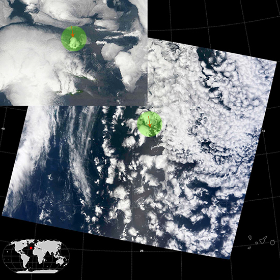
"We looked at retrievals from satellites cruising above an Atmospheric Radiation Measurement (ARM) Climate Research Facility site on an Atlantic island, where dozens of ground-based instruments pointed toward the sky are gathering data," said Dr. Steve Ghan, atmospheric scientist at PNNL. "Where the two sets of measurements diverge is droplet effective radius, a measurement that gives us important insight into how well a cloud reflects the sun's energy."
The work included researchers at the University of Maryland-Baltimore County, University of Arizona, University of North Dakota, Pacific Northwest National Laboratory, NASA Goddard Space Flight Center and NASA Langley Research Center.
Why It Matters: Clouds are the traffic cops of sunlight energy. They are major players in how the Earth's energy gets balanced. Clouds can let sunlight energy pass through, bounce it back to space or trap that energy close to Earth when it's reflected back off the surface. Clouds are famously difficult to represent when modeling the climate but are important to get right because of their huge impact on the Earth's energy balance. And as the climate changes, their role will become even more important to understand.
Satellites provide near global coverage of cloud measurements, while ground-based instruments provide higher accuracy. Retrieving cloud properties by satellite provides valuable checks on cloud simulations done by climate models, but even the accuracy of those retrievals is limited by assumptions about the properties of the surface below. Surface-based measurements (from the ground looking up) are not as affected by surface properties, so they are more accurate views than retrievals from space. Surface-based retrievals can therefore provide benchmark measurements for evaluating those from satellites. In this paper, researchers are specifically targeting the comparison to find which measurements agree more than others.
Methods: The research team used retrievals from the moderate-resolution imaging spectroradiometer (MODIS), a scientific instrument launched into Earth orbit on board the Terra and Aqua satellites. The team used two satellite-based data products. One was developed by the science team at NASA Goddard Space Flight Center from the MODIS-based cloud property products called GSFC-MODIS. A second was developed by the NASA Langley Research Center from the Clouds and Earth's Radiant Energy System (CERES) project, called CERES-MODIS. The ground-based cloud characterization instruments were deployed by the ARM Climate Research Facility mobile site at Graciosa Island in the Azores near Portugal for 21 months spanning 2009 to 2010. The ARM Mobile Facility instruments provided a variety of cloud and aerosol observations, as well as related radiation fields and meteorological conditions, key to understanding a number of environmental conditions that affect clouds.
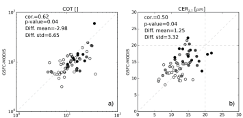
Cloud Views The two graphs show comparisons of cloud optical thickness (COT) and cloud effective radius (CER3.7) from the GSFC-MODIS cloud product with the ground-based retrievals. Image courtesy of authors.
In comparing the satellite and ground-based data, the co-location of the retrievals is critical. Ground-based instruments make single-point observations, whereas satellite imagers like MODIS take instantaneous snapshots of a large area. The MODIS instrument doesn’t pass exactly over the ARM site in the Azores, so the comparison of the retrievals was expressed in terms of the distance between the retrievals.
The team’s analysis found good agreement between two different sets of retrievals from the MODIS satellite instrument for cloud optical depth and droplet effective radius, and good agreement between MODIS and ARM retrievals of cloud optical depth. But the MODIS and ARM retrievals of droplet effective radius are consistently different. This difference was attributed to the different viewing angle of the instruments, with the MODIS sensing droplet radius near the cloud top and ARM sensing droplet radius near the cloud base, where droplets are smaller. As might be expected, the comparison of the MODIS and ARM retrievals depends on how close the retrievals were to each other.
What's Next? The researchers are now using this data to evaluate clouds simulated by global climate models.
Acknowledgments
Sponsor: This research was supported by the U.S. Department of Energy's Office of Science, Office of Biological and Environmental Research as part of the Regional and Global Climate Modeling Program.
User Facility: ARM Climate Research Facility, a DOE Office of Science User Facility
Research Team: Po-Lun Ma and Steven J. Ghan, PNNL; Zhibo Zhang and Hua Song, University of Maryland Baltimore County; Xiquan Dong, University of Arizona; Baike Xi, University of North Dakota; Steven Platnick, NASA Goddard Space Flight Center; and Patrick Minnis, NASA Langley Research Center.
Research Area: Climate and Earth Systems Science
Reference: Zhang Z, X Dong, B Xi, H Song, P-L Ma, S Ghan, S Platnick, and P Minnis. 2017. "Inter-comparisons of Marine Boundary Layer Cloud Properties from the ARM CAP-MBL Campaign and Two MODIS Cloud Products." Journal of Geophysical Research: Atmospheres 122(4):2351-2365. DOI: 10.1002/2016JD025763.